|
 |
|
||||
|
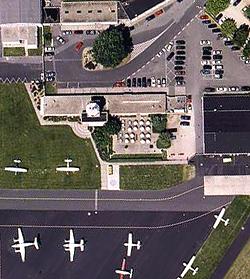
The Egelsbach Airfield is located within the European economic region Rhein-Main in close proximity to the international airport Frankfurt. The annual number of flight movements makes it the largest airfield for General Aviation in Germany. Approximately 2000 destinations can be reached nationally and internationally from Egelsbach nonstop. The airfield serves as a base for aeronautical maintenance companies, police helicopters, various aviation companies and flight clubs, airplane and helicopter flight schools, aerial photograph companies as well as a number of other aviation referred enterprises. The airfield and its complete infrastructure is ready to serve business travelers, passengers, pilots, student pilots and other guests and interested 365 days in the year. History: In Spring 1953 a model aircraft competition took place on the meadows located southwest of Egelsbach. It suggested itself to use this area also for soreing and motor flight. A north/south aligned grass runway existed in the beginnings of the airfield. The number of the flight movements constantly increased - the first statistic year 1956 already showed more than 37.000 movements. The settlement of companies and the building of hangars now progressed unstoppable. In 1962 250 people are employed at the airfield. During 1966 an asphalt runway was built and the number of aircraft movements rose to almost 100.000 nearly twice as much compared to 1963. In the course of time Egelsbach was approached by a multiplicity of different types of aircraft. One of the most beautiful types is doubtless the Ju52. Occasionally it is possible to admire one of the rare yet still airworthy aircraft in Egelsbach. The picture shows "The Old Aunts'" cockpit. Information on flights can be obtained with Deutschen Lufthansa Berlin-Stiftung. After almost 50 years of airfield history Egelsbach is now constant home base for more than 200 aircraft. More than 400 employees guarantee a comprehensive support of customers. Today the Egelsbach Airfield presents itself as an indispensable component of the economic region Rhein/Main. The desire for fast, flexible european-wide connections makes Egelsbach particularly attractive for business travelers.
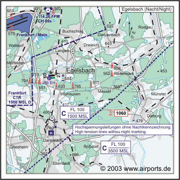
Kategorie Verkehrslandeplatz / Public Airfield Lage / Location 0.27 NM SW Egelsbach Zoll / Customs Während der Betriebszeit/During poerating hours,
einschließlich Handelsware/including merchandise Adresse Flugplatz Fon +49 (0)6103 / 9418-0 E-mail: fly at egelsbach-airport com WWW: http://www.egelsbach-airport.com/
Images and information placed above are from http://www.airports.de/airport.php?ICAO=EDFE We thank them for the data!
Runway 09/274593 x 82 feet
|
|||||||||||||||||||||||||||||||||||||||||||||||||||||||||||||||||||||||||||||||||||||||||||||||||||||||||||||||||||||||||||||||||||||||||||||||||||||||||||||||||||||||||||||||||||||||||||||||||||||||||||||||||||||||||||||||
| Runway 09 | |
|---|---|
| Surface | ASPHALT |
| True Heading | 086.0 |
| Latitude | 49.960353 49° 57' 37.27" N |
| Longitude | 8.631772 008° 37' 54.38" E |
| Landing Distance | 4593 feet 1400 meters |
| Takeoff Distance | 4593 feet 1400 meters |
| Lighting System | LIRL
LIGHTS |
| Runway 27 | |
|---|---|
| Surface | ASPHALT |
| True Heading | 266.0 |
| Latitude | 49.961314 49° 57' 40.73" N |
| Longitude | 8.651228 008° 39' 04.42" E |
| Landing Distance | 3829 feet 1167 meters |
| Takeoff Distance | 4888 feet 1490 meters |
| Displaced Threshold Length | 764 feet 233 meters |
| Overrun Length | 295 feet 90 meters |
| Overrun Surface | ASPHALT |
| Lighting System | LIRL
PAPI LIGHTS |
| Runway 09R | |
|---|---|
| Surface | GRASS OR EARTH NOT GRADED OR ROLLED. |
| True Heading | 086.0 |
| Latitude | 49.958667 49° 57' 31.20" N |
| Longitude | 8.642028 008° 38' 31.30" E |
| Landing Distance | 1279 feet 390 meters |
| Takeoff Distance | 2198 feet 670 meters |
| Displaced Threshold Length | 919 feet 280 meters |
| Runway 27L | |
|---|---|
| Surface | GRASS OR EARTH NOT GRADED OR ROLLED. |
| True Heading | 266.0 |
| Latitude | 49.959083 49° 57' 32.70" N |
| Longitude | 8.651389 008° 39' 05.00" E |
| Landing Distance | 1706 feet 520 meters |
| Takeoff Distance | 2198 feet 670 meters |
| Displaced Threshold Length | 492 feet 150 meters |
| EGELSBACH | |||||
|---|---|---|---|---|---|
| Type | ID | Channel | Freq | Country | State |
| NDB | EH | - | 386 | Germany | - |
| Latitude | Longitude | Airport |
| 49.960064 49° 57' 36.23" N |
8.642631 008° 38' 33.47" E |
EDFE |
The content above was published at Airports-Worldwide.com in 2005.
We don't guarantee the information is fresh and accurate. The data may be wrong or outdated.
For more up-to-date information please refer to other sources.

 |
|
Copyright 2004-2024 © by Airports-Worldwide.com, Vyshenskoho st. 36, Lviv 79010, Ukraine Legal Disclaimer |