 |
|
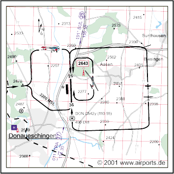
Donaueschingen Villingen Airfield |
ICAO Code EDTD
Name DONAUESCHINGEN - Villingen
Land Deutschland
Bundesland Baden-Württemberg
Letzte Änderung 22. Oktober 2003
Kategorie Verkehrslandeplatz / Public Airfield
Betreiber / Operator Flugplatz Donaueschingen-Villingen GmbH
Lage / Location 1.6 NM NE Donaueschingen
Nachtflug / NVFR NVFR PPR
Instrumentenflug / IFR IFR
LFZ / ACFT Bis / up to 5700 kg, 12000 kg PPR
Helicopter Ja / Yes
Motorsegler / GLDP Ja / Yes
Segelflugzeuge / GLD Ja / Yes
UL Ja / Yes
Summer 0600-SS/1830, SR-0600, SS/1830-SS+30 PPR
Winter 0700-SS, SR-30-0700 und/and SS-SS+30 PPR
Einschränkungen siehe AIP AD 1-6/ restrictions see chart section
and AIP AD 1-6
Luftaufsicht / OPS +49 (0)771 / 2585, Fax 14483
PPR +49 (0)771 / 2585, 0172 3403218
AIS AIS-Centre EDDZ, +49 (0)69 / 78072500
ACC EDDF +49 (0)6103 / 7076200
APP LSZH +41 18163908
MET (0190) 077227
Gafor 62
Zoll / Customs Flüge ins Ausland während der Betriebszeit/Exits
during operating hours, (0771) 2585 Für nichtgewerblichen Verkehr
und gewerblichen Gelegenheitsverkehr ohne Handelsware. Bei Ein-und Ausflügen
ais/in Drittländern (nicht EU) PPR MNM 2 HR bei OPS. / Flights abroad
during operating hours (0771) 2585. For non-commecial traffic without
merchandise. For entries and departures from third countries (non EU)
PPR MNM 2 HR from OPS
Zoll / Customs Fon +49 (0)771 / 2585
Fuel 100 LL Jet A1
Oil D 80, D 100, 15W50 andere Sorten/other grades PPR
Hangar Beschränkt / Limited
Höhe / Elevation 2227 ft / 679 m
FIS Zürich Information 124.700
VDF / QDM 124.250
Rufzeichen / Call sign Donaueschingen Info
Frequenz Tower 124.250 EN / GE 122.500 EN / GE
NAV Aids NDB DVI 490DMI 11055 am Platz/ at field 192°/25 NM from SUL
VOR 116.10 013°/18 NM from TRA VOR/DME 114.30/Ch 90
Koordinaten 47 58, 41 N / 08 31, 33 E
Platzrunde / Traffic circuit W 3200
Landebahnen / RWY 1
RWY 1200 x 20 m, ASPHALT
RWY 18 TKOF 1200 m; LDG 1290 m
RWY 36 TKOF 1290 m; LDG 1200 m
MTOW 5700 kg, PPR 12000 kg
Bemerkungen / Remarks Hindernis/OBST 0.4 NM ENE THR 18 (2643 MSL)! GLD
E des Platzes! Wohngebiete meiden! UL acft PPR!
Restaurant - Yes
Adresse
Dürrheimerstr. 80 c
ZIP / City D-78166 Donaueschingen
Fon +49 (0)771 / 162233
WWW: http://www.airports.de/airport.php?ICAO=EDTD
Images and information placed above are from
http://www.airports.de/airport.php?ICAO=EDTD
We thank them for the data!
| General Info
|
| Country |
Germany
|
| ICAO ID |
EDTD
|
| Time |
UTC+1(+2DT)
|
| Latitude |
47.973331
47° 58' 23.99" N
|
| Longitude |
8.522222
008° 31' 20.00" E
|
| Elevation |
2231 feet
680 meters
|
| Type |
Civil
|
| Magnetic Variation |
000° E (01/05)
|
| Beacon |
Yes
|
| Operating Agency |
CIVIL GOVERNMENT, (LANDING FEES AND DIPLOMATIC CLEARANCE MAY BE REQUIRED)
|
| Operating Hours |
SEE REMARKS FOR OPERATING HOURS OR COMMUNICATIONS FOR POSSIBLE HOURS
|
| Daylight Savings Time |
Last Sunday in March to last Sunday in October
|
| Communications
|
| INFO |
124.25
122.5
|
| ZURICH ARR |
120.75
|
| Runways
|
ID
|
Dimensions |
Surface |
PCN |
ILS
|
| 18/36 |
4232 x 98 feet
1290 x 30 meters |
ASPHALT |
- |
NO
|
| Navaids
|
| Type |
ID |
Name |
Channel |
Freq |
Distance From Field |
Bearing From Navaid
|
| NDB |
DVI |
DONAUESCHINGEN |
- |
490 |
At Field |
-
|
| DME |
DON |
DONAUESCHINGEN |
042Y |
- |
At Field |
-
|
| Supplies/Equipment
|
| Fuel |
Jet A, without icing inhibitor.
100/130 MIL Spec, low lead, aviation gasoline (BLUE)
|
| Remarks
|
| CSTMS/AG/IMG |
Avbl 0700Z++-SS, O/R 30 min PN. C0771-2585. Only for non-coml tfc w/o merchandise. 2hr PN for dep or arr from non-EUR countries.
|
| FUEL |
(NC-100LL, A1)
|
| NS ABTMT |
Before 0600Z++, btn 1200-1400Z++, aft SS Mon-Fri. Before 0800Z++ and aft 1200Z++Sat, Sun, hol.
|
| OPR HOURS |
Opr 0700Z-SS, O/T PPR; (0600Z-SS or 1830Z, O/T PPR DT).
|
| RWY |
TODA Rwy 36 is 3937'. PPR for acft up to AUW26.4.
|
Runway 18/36
4232 x 98 feet
1290 x 30 meters
| Runway 18
|
| Surface |
ASPHALT
|
| True Heading |
179.0
|
| Latitude |
47.979864
47° 58' 47.51" N
|
| Longitude |
8.521958
008° 31' 19.05" E
|
| Elevation |
2230.0 feet
680 meters
|
| Slope |
-0.3°
|
| Landing Distance |
3937 feet
1200 meters
|
| Takeoff Distance |
4232 feet
1290 meters
|
| Displaced Threshold Length |
295 feet
90 meters
|
| Lighting System |
HIRL
REIL |
| Runway 36
|
| Surface |
ASPHALT
|
| True Heading |
359.0
|
| Latitude |
47.968267
47° 58' 05.76" N
|
| Longitude |
8.522414
008° 31' 20.69" E
|
| Elevation |
2219.0 feet
676 meters
|
| Slope |
0.3°
|
| Landing Distance |
4232 feet
1290 meters
|
| Takeoff Distance |
4232 feet
1290 meters
|
| Lighting System |
HIRL
REIL
T |
Navaids
| DONAUESCHINGEN
|
| Type |
ID |
Channel |
Freq |
Country |
State
|
| NDB |
DVI |
- |
490 |
Germany |
-
|
| Latitude |
Longitude |
Airport
|
47.960722
47° 57' 38.60" N |
8.522708
008° 31' 21.75" E |
EDTD |
Navaids
| DONAUESCHINGEN
|
| Type |
ID |
Channel |
Freq |
Country |
State
|
| DME |
DON |
042Y |
- |
Germany |
-
|
| Latitude |
Longitude |
Airport
|
47.960681
47° 57' 38.45" N |
8.522553
008° 31' 21.19" E |
EDTD |
The content above was published at Airports-Worldwide.com in 2005.
We don't guarantee the information is fresh and accurate. The data may be wrong or outdated.
For more up-to-date information please refer to other sources.
|
|


