 |
|
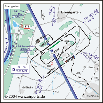
ICAO Code EDTG
Name BREMGARTEN
Land Deutschland
Bundesland Baden-Württemberg
Letzte Änderung 9. April 2004
Kategorie Sonderlandeplatz / Special Airfield
Betreiber / Operator Zweckverband Gewerbepark Breisgau Sonderlandeplatz
Lage / Location 1.6 NM W Eschbach
LFZ / ACFT Bis / up to 20000 kg ASPH, 5700 kg Gras, HEL 10000 kg
Helicopter Ja / Yes
Motorsegler / GLDP Ja / Yes
Segelflugzeuge / GLD Ja / Yes
UL Ja / Yes
Fallschirmspringen / PJE Ja / Yes
Summer MON-FRI 0730-1800/SS+30, SAT,SUN,HOL 1030-1200 keine Starts aus
Lärmgründen/No Dep due to noise
Winter MON-FRI 0830-SS+30, SAT SUN, HOL 1130-1300 keine Starts aus Lärmgründen/No
Deo due to noise
O/T PPR
Sat, Sun, HOL 1130-1300 keine Starts aus Lärmgründen/No DEP
due to noise. Weitere einschränkungen siehe AD 1-6/Additional restrictions
see AD 1-6
Luftaufsicht / OPS +49 (0)7634 / 510817, Fax 510818
AIS AIS-Centre EDDZ, +49 (0)69 / 78072500
ACC EDDF +49 (0)6103 / 7076200
APP LFSB +33 389902641
MET (0190) 077227
Gafor 51
Zoll / Customs Nein / No
Fuel 100 LL, Jet A1, Super bleifrei/ unleaded 95 Okt. Kein/no Carnet
Oil D 80, D 100 SAE 20W50
Hangar O / R
Höhe / Elevation 695 ft / 212 m
FIS Langen Information 128.950
Rufzeichen / Call sign Bremgarten Info
Frequenz Tower 122.000 GE
NAV Aids 017°/17 NM from BLM VOR/DME 117.45/Ch 121y 178°/36 NM
from STR VOR/DME 115.60/Ch 103 292°/26 NM from TRA VOR/DME 114.30
- 236°/50 NM from SUL 116.10
Koordinaten 47 54, 19 N / 07 37, 07 E
Platzrunde / Traffic circuit SE 1500/1300
Landebahnen / RWY 2
RWY 1650 x 45 m, ASPHALT
RWY 05 TKOF 1650 m; LDG 1650 m
RWY 23 TKOF 1650 m; LDG 1650 m
MTOW 20000 kk, HEL 10000 kg
RWY II 600 x 30 m, Gras
RWY 05 TKOF 600 m; LDG 600 m
RWY 23 TKOF 600 m; LDG 600 m
MTOW RWY II 2000 kg
Bemerkungen / Remarks GLD + PJE! UL-Betrieb! Wohngebiete meiden!
Restaurant - Yes
Adresse
Hartheimer Str. 12
ZIP / City D-79427 Eschbach
Fon +49 (0)7634 / 510810
Fax 510822
WWW: http://www.airports.de/airport.php?ICAO=EDTG
Images and information placed above are from
http://www.airports.de/airport.php?ICAO=EDTG
We thank them for the data!
| General Info
|
| Country |
Germany
|
| ICAO ID |
EDTG
|
| Time |
UTC+1(+2DT)
|
| Latitude |
47.903167
47° 54' 11.40" N
|
| Longitude |
7.617833
007° 37' 04.20" E
|
| Elevation |
695 feet
212 meters
|
| Magnetic Variation |
000° E (01/05)
|
| Operating Agency |
PRIVATE
|
| Alternate Name |
ESCHBACH
|
| Operating Hours |
SEE REMARKS FOR OPERATING HOURS OR COMMUNICATIONS FOR POSSIBLE HOURS
|
| Daylight Savings Time |
Last Sunday in March to last Sunday in October
|
| Communications
|
| INFO |
122.0
|
| LANGEN INFO |
128.95
|
| Runways
|
ID
|
Dimensions |
Surface |
PCN |
ILS
|
| 05/23 |
5413 x 148 feet
1650 x 45 meters |
ASPHALT |
- |
NO
|
| 05R/23L |
1969 x 98 feet
600 x 30 meters |
GRASS OR EARTH NOT GRADED OR ROLLED. |
- |
NO
|
| Supplies/Equipment
|
| Fuel |
Jet A1, without icing nhibitor.
100/130 MIL Spec, low lead, aviation gasoline (BLUE)
|
| Remarks
|
| CAUTION |
Copter, gldr, ultralgt and PJE act.
|
| FUEL |
(NC-100LL, A1)
|
| MISC |
Sod gldr strip S of ASP rwy.
|
| OPR HOURS |
Opr 0830Z-SS+30 Mon-Fri, (0730Z-1800Z/SS+30 DT); No dep 1130-1300Z++Sat, Sun and hol.
|
Runway 05/23
5413 x 148 feet
1650 x 45 meters
| Runway 05
|
| Surface |
ASPHALT
|
| True Heading |
053.0
|
| Latitude |
47.898722
47° 53' 55.40" N
|
| Longitude |
7.608997
007° 36' 32.39" E
|
| Landing Distance |
5413 feet
1650 meters
|
| Takeoff Distance |
5659 feet
1725 meters
|
| Overrun Length |
246 feet
75 meters
|
| Overrun Surface |
ASPHALT
|
| Runway 23
|
| Surface |
ASPHALT
|
| True Heading |
233.0
|
| Latitude |
47.907608
47° 54' 27.39" N
|
| Longitude |
7.626672
007° 37' 36.02" E
|
| Landing Distance |
5413 feet
1650 meters
|
| Takeoff Distance |
5659 feet
1725 meters
|
| Overrun Length |
246 feet
75 meters
|
| Overrun Surface |
ASPHALT
|
Runway 05R/23L
1969 x 98 feet
600 x 30 meters
| Runway 05R
|
| Surface |
GRASS OR EARTH NOT GRADED OR ROLLED.
|
| True Heading |
053.0
|
| Latitude |
0.000000
-
|
| Longitude |
0.000000
-
|
| Landing Distance |
1969 feet
600 meters
|
| Takeoff Distance |
1969 feet
600 meters
|
| Runway 23L
|
| Surface |
GRASS OR EARTH NOT GRADED OR ROLLED.
|
| True Heading |
233.0
|
| Latitude |
0.000000
-
|
| Longitude |
0.000000
-
|
| Landing Distance |
1969 feet
600 meters
|
| Takeoff Distance |
1969 feet
600 meters
|
The content above was published at Airports-Worldwide.com in 2005.
We don't guarantee the information is fresh and accurate. The data may be wrong or outdated.
For more up-to-date information please refer to other sources.
|
|


