|
 |
|
||||
|
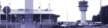
Our passengers will find their ways in the clearly arranged terminal with its ease of use and relaxed atmosphere. In our terminal you can find: • Information desk of the Airport and the Airline Ryanair • Tourist-Information desk • Car hire Hertz and Europcar • Airport Café • Travel Value Shop • Cash dispenser • Free parking lots • Taxis • Bus stop • Snack bar Information: ICAO Code EDAC Kategorie Verkehrslandeplatz / Public Airfield Verwaltung Telefon 0 34 47 - 59 00 WWW: http://www.flughafen-altenburg.de/
Images and information placed above are from http://www.flughafen-altenburg.de/ http://www.airports.de/airport.php?ICAO=EDAC We thank them for the data!
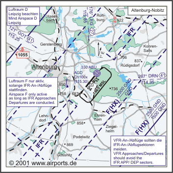
Runway 04/227333 x 148 feet
|
||||||||||||||||||||||||||||||||||||||||||||||||||||||||||||||||||||||||||||||||||||||||||||||||||||||||||||||||||||||||||||||||||||||||||||||||||||||||||||||||||||||||||||||||||||||||||||||||||||||||||||||||||||||||||||||||
| Runway 04 | |
|---|---|
| Surface | CONCRETE. |
| True Heading | 041.0 |
| Latitude | 50.974369 50° 58' 27.73" N |
| Longitude | 12.496222 012° 29' 46.40" E |
| Elevation | 633.0 feet 193 meters |
| Slope | -0.5° |
| Landing Distance | 6480 feet 1975 meters |
| Takeoff Distance | 7989 feet 2435 meters |
| Displaced Threshold Length | 853 feet 260 meters |
| Overrun Length | 656 feet 200 meters |
| Overrun Surface | CONCRETE. |
| Lighting System | SF
HIRL REIL BO PAPI |
| Runway 22 | |
|---|---|
| Surface | CONCRETE. |
| True Heading | 221.0 |
| Latitude | 50.989261 50° 59' 21.34" N |
| Longitude | 12.516506 012° 30' 59.42" E |
| Elevation | 595.0 feet 181 meters |
| Slope | 0.5° |
| Landing Distance | 6348 feet 1935 meters |
| Takeoff Distance | 7760 feet 2365 meters |
| Displaced Threshold Length | 985 feet 300 meters |
| Overrun Length | 427 feet 130 meters |
| Overrun Surface | CONCRETE. |
| Lighting System | SF
HIRL REIL BO PAPI |
| ALTENBURG | |||||
|---|---|---|---|---|---|
| Type | ID | Channel | Freq | Country | State |
| NDB | ABU | - | 330 | Germany | - |
| Latitude | Longitude | Airport |
| 50.993772 50° 59' 37.58" N |
12.521033 012° 31' 15.72" E |
EDAC |
| ALTENBURG | |||||
|---|---|---|---|---|---|
| Type | ID | Channel | Freq | Country | State |
| DME | AGD | 100X | - | Germany | - |
| Latitude | Longitude | Airport |
| 50.982669 50° 58' 57.61" N |
12.512261 012° 30' 44.14" E |
EDAC |
The content above was published at Airports-Worldwide.com in 2005.
We don't guarantee the information is fresh and accurate. The data may be wrong or outdated.
For more up-to-date information please refer to other sources.

 |
|
Copyright 2004-2026 © by Airports-Worldwide.com, Vyshenskoho st. 36, Lviv 79010, Ukraine Legal Disclaimer |