|
ICAO Code EDBT
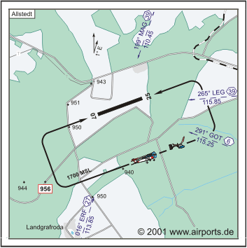
Name ALLSTEDT
Land Deutschland
Bundesland Sachsen-Anhalt Letzte
Änderung 7. Februar 2003
Kategorie Sonderlandeplatz / Special Airfield
Betreiber / Operator SSG Städtische Sanierungsgesellschaft Sangerhausen
mbH
Adresse Am Brühl 7
ZIP / City D-06526 Sangerhausen
Fon +49 (0)3464 / 27500
Fax 275050
Internet Nein
Lage / Location 1.8 NM SE Allstedt
LFZ / ACFT Bis / up to 5700 kg, 14000 kg PPR
Helicopter Ja / Yes
Motorsegler / GLDP Ja / Yes
Segelflugzeuge / GLD Ja / Yes
Ballone Ja / Yes
UL Ja / Yes
H-GLD, P-GLD, Luftschiffe/airships, Flugmodelle/flying models
Summer SAT, SUN, HOL 0700-SS+30/1700 PPR
Winter 0700-SS+30 PPR
O/T PPR
Luftaufsicht / OPS +49 (0)1805444730
PPR +49 (0)1805444730
AIS EDDB +49 (0)30 / 60918250
MET (0190) 077226
Gafor 21
Zoll / Customs Nein / No
Fuel O/R
Oil O/R
Hangar O/R
Höhe / Elevation 932 ft / 284 m
FIS Berlin Information 125.800
Rufzeichen / Call sign Allstedt INFO
Frequenz Tower 122.000 GE
NAV Aids 199°/39 NM from MAG 110.45 - 265°/39 NM from LEG 115.85
- 291°/6 NM from GOT 115.25 - 016°/27 NM from ERF 113.85
Koordinaten 51 22, 83 N / 11 26, 80 E
Platzrunde / Traffic circuit SE 1700
Landebahnen / RWY 1
RWY 1200 x 30 m, CONCRETE
RWY 07 TKOF 1200 m; LDG 1200 m
RWY 25 TKOF 1200 m; LDG 1200 m
MTOW 5700 kg, PPR 14000 kg
WWW: http://www.airports.de/airport.php?ICAO=EDBT
Images and information placed above are from
http://www.airports.de/airport.php?ICAO=EDBT
We thank them for the data!
| General Info
|
| Country |
Germany
|
| ICAO ID |
EDBT
|
| Time |
UTC+1(+2DT)
|
| Latitude |
51.380500
51° 22' 49.80" N
|
| Longitude |
11.446667
011° 26' 48.00" E
|
| Elevation |
932 feet
284 meters
|
| Magnetic Variation |
001° E (01/05)
|
| Operating Agency |
PRIVATE
|
| Alternate Name |
QUERFURT
|
| Operating Hours |
SEE REMARKS FOR OPERATING HOURS OR COMMUNICATIONS FOR POSSIBLE HOURS
|
| Daylight Savings Time |
Last Sunday in March to last Sunday in October
|
| Communications
|
| BERLIN INFO |
125.8
|
| INFO |
122.0
|
| Runways
|
ID
|
Dimensions |
Surface |
PCN |
ILS
|
| 07/25 |
3937 x 98 feet
1200 x 30 meters |
CONCRETE. |
- |
NO
|
| Supplies/Equipment
|
| Fuel |
Unknown fuel type or whether there is any fuel.
|
| Remarks
|
| CAUTION |
Extv copter, gldr and unmanned acft ops.
|
| FUEL |
(NC-100LL)
|
| OPR HOURS |
Opr 0700Z-SS+30/1900Z, OT PPR.
|
| RSTD |
PPR for acft AUW 12.5 to AUW 30.8.
|
Runway 07/25
3937 x 98 feet
1200 x 30 meters
| Runway 07
|
| Surface |
CONCRETE.
|
| True Heading |
070.0
|
| Latitude |
51.376847
51° 22' 36.65" N
|
| Longitude |
11.429025
011° 25' 44.49" E
|
| Landing Distance |
3937 feet
1200 meters
|
| Takeoff Distance |
3937 feet
1200 meters
|
| Runway 25
|
| Surface |
CONCRETE.
|
| True Heading |
250.0
|
| Latitude |
51.380547
51° 22' 49.97" N
|
| Longitude |
11.445214
011° 26' 42.77" E
|
| Landing Distance |
3937 feet
1200 meters
|
| Takeoff Distance |
3937 feet
1200 meters
|
The content above was published at Airports-Worldwide.com in 2005.
We don't guarantee the information is fresh and accurate. The data may be wrong or outdated.
For more up-to-date information please refer to other sources.
|


