|
|
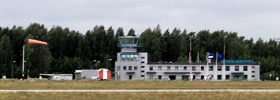
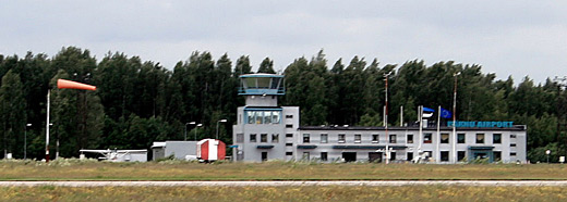
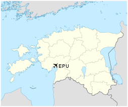
| Pärnu Airport |
 |
IATA: EPU – ICAO: EEPU
 |
| Summary |
| Airport type |
Public |
| Operator |
Tallinn Airport Ltd. |
| Location |
Pärnu |
| Elevation AMSL |
46 ft / 14 m |
| Coordinates |
58°25′09″N 024°28′22″E / 58.41917°N 24.47278°E / 58.41917; 24.47278Coordinates: 58°25′09″N 024°28′22″E / 58.41917°N 24.47278°E / 58.41917; 24.47278 |
| Runways |
| Direction |
Length |
Surface |
| ft |
m |
| 03/21 |
8,136 |
2,480 |
Concrete |
Pärnu Airport (IATA: EPU, ICAO: EEPU) is an airport in Estonia. The airport is situated 4 km (2½ mi) from the city of Pärnu.
In October 1937 Pärnu town council gave an area of 0.28 km² (69 ac) for building of an airport. The first plane took off from the airport in 1939.
During the Soviet occupation, the airfield was operated by the Soviet Air Force. It was an interceptor aircraft base, operated by 366 IAP (366th Interceptor Aviation Regiment) and possibly the 655 IAP (655th Interceptor Aviation Regiment), which flew MiG-23 aircraft from the 1970s until the 1990s .
Aeroflot used to run Tartu-Viljandi-Pärnu-Kingissepa (now Kuressaare) civil service using AN-2 planes.
In the summer of 1992, the re-constituted Estonian defence ministry took over the military airport, which had drawn down its operations. On 15 October the same year it was decided to build a civil airport at the site of the old military airport. The old runway was closed on 1 July 1997, and regular flights started to use the runway that had belonged to the Soviet air force.
The small airline Air Livonia flies from Pärnu to Kuressaare, Kihnu and Ruhnu. The airport is often visited by private airplanes from Scandinavia and other European countries. 5,035 people travelled via Pärnu Airport in 2004.
Airlines and destinations
| Airlines |
Destinations |
| Avies |
Kihnu |
| Estonian Air Regional |
Stockholm-Arlanda |
| LFH – Luftverkehr Friesland Harle |
Ruhnu |
The above content comes from Wikipedia and is published under free licenses – click here to read more.
| General Info
|
| Country |
Estonia
|
| ICAO ID |
EEPU
|
| Time |
UTC+2(+3DT)
|
| Latitude |
58.419044
58° 25' 08.56" N
|
| Longitude |
24.472819
024° 28' 22.15" E
|
| Elevation |
47 feet
14 meters
|
| Type |
Civil
|
| Magnetic Variation |
006° E (01/06)
|
| Operating Agency |
CIVIL GOVERNMENT, (LANDING FEES AND DIPLOMATIC CLEARANCE MAY BE REQUIRED)
|
| Daylight Saving Time |
Last Sunday in March to last Sunday in October
|
| Communications
|
AFIS
Opr HO.
|
132.0
|
| Runways
|
| ID |
Dimensions |
Surface |
PCN |
ILS
|
| 03/21 |
8136 x 148 feet
2480 x 45 meters |
CONCRETE. |
- |
NO
|
| Navaids
|
| Type |
ID |
Name |
Channel |
Freq |
Distance From Field |
Bearing From Navaid
|
| VOR-DME |
PRN |
PARNU |
106X |
115.9 |
At Field |
-
|
| NDB |
RC |
PARNU |
- |
425 |
5.3 NM |
209.8
|
| Supplies/Equipment
|
| Fuel |
Jet A1, without icing nhibitor.
100/130 MIL Spec, low lead, aviation gasoline (BLUE)
|
| Remarks
|
| CSTMS/IMG |
Avbl, 1 hr PN.
|
| FUEL |
24 hr PN for more than 264 gal, fone C+372 44 75008/75001. (NC-100LL, A1)
|
| OPR HOURS |
Opr 0600-1500Z++, OT O/R, fone C+372 44 75000, FAX C+372 44 75002.
|
The content above was published at Airports-Worldwide.com in 2010.
We don't guarantee the information is fresh and accurate. The data may be wrong or outdated.
For more up-to-date information please refer to other sources.
|
|