 |
|
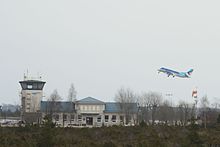
Kuressaare Airport
Kuressaare lennujaam |
 |
| IATA: URE – ICAO: EEKE |
| Summary |
| Airport type |
Public |
| Operator |
Kuressaare Lennujaam |
| Location |
Kuressaare |
| Elevation AMSL |
14 ft / 4 m |
| Coordinates |
58°13′47″N 22°30′34″E / 58.22972°N 22.50944°E / 58.22972; 22.50944Coordinates: 58°13′47″N 22°30′34″E / 58.22972°N 22.50944°E / 58.22972; 22.50944 |
| Runways |
| Direction |
Length |
Surface |
| ft |
m |
| 17/35 |
4,980 |
1,518 |
Asphalt |
| 05/23 |
2,621 |
799 |
Asphalt |
Kuressaare Airport (IATA: URE, ICAO: EEKE) is an airport in Estonia. The airport is situated 3 km from the town of Kuressaare on Saaremaa island.
The first runway was built in the last half of the 1930s. The airport was opened officially on 6 March 1945. The air traffic increased during the next years, and between 1949 and 1953 there were from 10 to 14 flights every day between Kuressaare and Tallinn. During this period around 400 passengers flew to or from Kuressaare each day. The airport didn't get electricity until 1958. The present terminal building was built in 1962. The second runway 05/23 was built in 1976 and on 1999 the main runway was lengthened. The terminal building was modernized in 2007.
The airport is owned by AS Tallinna Lennujaam. It also owns the Ruhnu Airfield.
19 519 passengers travelled via Kuressaare Airport in 2009.
Scheduled airlines and destinations
| Airlines |
Destinations |
| Estonian Air Regional |
Stockholm-Arlanda, Tallinn |
| LFH – Luftverkehr Friesland Harle |
Ruhnu |
The above content comes from Wikipedia and is published under free licenses – click here to read more.
| General Info
|
| Country |
Estonia
|
| ICAO ID |
EEKE
|
| Time |
UTC+2(+3DT)
|
| Latitude |
58.229883
58° 13' 47.58" N
|
| Longitude |
22.509494
022° 30' 34.18" E
|
| Elevation |
14 feet
4 meters
|
| Magnetic Variation |
005° E (01/06)
|
| Operating Agency |
CIVIL GOVERNMENT, (LANDING FEES AND DIPLOMATIC CLEARANCE MAY BE REQUIRED)
|
| Operating Hours |
SEE REMARKS FOR OPERATING HOURS OR COMMUNICATIONS FOR POSSIBLE HOURS
|
| Daylight Saving Time |
Last Sunday in March to last Sunday in October
|
| Communications
|
TWR
Opr HO.
|
118.05
|
| Runways
|
| ID |
Dimensions |
Surface |
PCN |
ILS
|
| 05/23 |
2621 x 98 feet
799 x 30 meters |
ASPHALT |
- |
NO
|
| 17/35 |
4980 x 98 feet
1518 x 30 meters |
ASPHALT |
- |
NO
|
| Navaids
|
| Type |
ID |
Name |
Channel |
Freq |
Distance From Field |
Bearing From Navaid
|
| VOR-DME |
KRS |
KURESSAARE |
071X |
112.4 |
At Field |
-
|
| NDB |
WA |
KURESSAARE |
- |
350 |
2.5 NM |
174.2
|
| Supplies/Equipment
|
| Fuel |
100/130 MIL Spec, low lead, aviation gasoline (BLUE)
|
| Remarks
|
| CSTMS/IMG |
Avbl 0600-2000Z++ dly.
|
| FLUID |
De-Ice
|
| FUEL |
Opr 0500-1700Z++ Mon, Wed, Thu, Fri; 0600-1600Z++ Tue; 0600-1500Z++ Sat; 0600-1700Z++ Sun. (NC-100LL, A1)
|
| MISC |
Class D Airspace eff twr hr, OT Class G.
|
| OPR HOURS |
Opr 0600-1500Z++ Mon-Fri; OT O/R C+372 45 33790.
|
The content above was published at Airports-Worldwide.com in 2010.
We don't guarantee the information is fresh and accurate. The data may be wrong or outdated.
For more up-to-date information please refer to other sources.
|
|


