 |
|
Coordinates: 25°40′15″N 032°42′23″E / 25.67083°N 32.70639°E / 25.67083; 32.70639
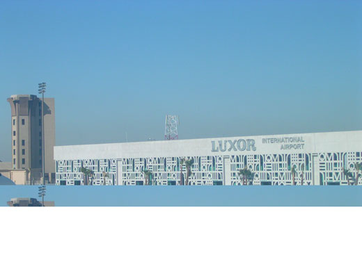
| Luxor International Airport |
 |
| IATA: LXR – ICAO: HELX |
| Summary |
| Airport type |
Public, Military |
| Operator |
Egyptian Airport Company |
| Serves |
Luxor, Egypt |
| Elevation AMSL |
294 ft / 90 m |
| Website |
www.luxor-airport.com |
| Runways |
| Direction |
Length |
Surface |
| m |
ft |
| 02/20 |
3,000 |
9,842 |
Asphalt |
| Sources: Airport web site and DAFIF |
Luxor International Airport Luxor International Airport (IATA: LXR, ICAO: HELX) is the main airport serving the city of Luxor, Egypt. It is located four miles (6km) east of the city.
Many charter airlines use the airport, as it is a popular tourist destination for those visiting the River Nile and the Valley of the Kings.
In 2009, the airport served 1,872,070 passengers (-13.7% vs. 2008).
In 2005 the airport was upgraded to accommodate up to 8 million passengers a year. Facilities for passengers include 48 check-in desks, 8 gates, 5 baggage claim belts, a post office, a bank, a Bureau de Change, an auto exchange machine (CIB), restaurants, cafeterias, a VIP Lounge, a duty free shop, a newsagent/tobacconist, a chemist shop, a gift shop, a travel agent, a tourist help desk, car rental, first aid, a baby/parent Room, disabled access/facilities and a business centre.
Facilities for cargo include refrigerated storage, animal quarantine, livestock handling, health officials, X-Ray equipment, and fumigation equipment.
The cargo terminal handling agent for the airport is EgyptAir Cargo. Airlines and destinations
Luxor is served by the following scheduled airlines:
| Airlines |
Destinations |
| Air Arabia |
Sharjah |
| Air Berlin |
Berlin-Tegel, Düsseldorf, Hamburg [begins 4 November, seasonal], Hanover, Leipzig/Halle, Munich [begins 5 November, seasonal], Nuremberg [begins 4 November, seasonal] |
| Air Berlin operated by Belair |
Basel [begins 4 November, seasonal], Zürich |
| Air Méditerranée |
Lyon, Paris-Charles de Gaulle |
| Arkefly |
Amsterdam |
| Bahrain Air |
Bahrain |
| easyJet |
London Gatwick [begins 3 November] |
| Edelweiss Air |
Zurich |
| EgyptAir |
Abu Simbel, Aswan, Barcelona [ends 25 October], Cairo, Kuwait, London-Heathrow, Madrid [ends 25 October], Milan [ends 25 October], Osaka-Kansai, Paris-Charles de Gaulle [ends 30 October], Rome [ends 25 October] |
| EgyptAir operated by EgyptAir Express |
Abu Simbel, Alexandria, Aswan, Cairo, Marsa Alam [begins 1 November], Sharm el-Sheikh |
| Flydubai |
Dubai |
| Jazeera Airways |
Kuwait |
| Jetairfly |
Brussels |
| Kuwait Airways |
Kuwait |
| Luxair |
Luxembourg |
| Monarch Airlines |
London-Gatwick, Manchester |
| Niki |
Salzburg, Vienna [both begin 4 November, seasonal] |
| Qatar Airways |
Doha |
| Thomas Cook Airlines |
London-Gatwick, Manchester |
| Thomas Cook Airlines (Belgium) |
Brussels |
| Thomson Airways |
Birmingham, Bristol [begins 3 November; seasonal], London-Gatwick, Manchester |
| transavia.com France |
Paris-Orly |
| TUIfly |
Berlin-Tegel, Cologne/Bonn, Düsseldorf, Frankfurt, Hanover, Munich, Stuttgart [all seasonal] |
| Wind Jet |
Catania |
Additionally, several airlines operate charter flights into the airport, including AlMasria Universal Airlines, AMC Airlines (which are based there), Hamburg International and Neos.
Accidents and incidents
On 20 February 2009, an Antonov An-12 of Aerolift crashed after an engine caught fire on take-off. All five crew were killed.
The above content comes from Wikipedia and is published under free licenses – click here to read more.
| General Info
|
| Country |
Egypt
|
| ICAO ID |
HELX
|
| Time |
UTC+2(+3DT)
|
| Latitude |
25.671028
25° 40' 15.70" N
|
| Longitude |
32.706583
032° 42' 23.70" E
|
| Elevation |
294 feet
90 meters
|
| Type |
Civil
|
| Magnetic Variation |
003° E (01/06)
|
| Beacon |
Yes
|
| Operating Agency |
CIVIL GOVERNMENT, (LANDING FEES AND DIPLOMATIC CLEARANCE MAY BE REQUIRED)
|
| Operating Hours |
UNKNOWN
|
| Daylight Saving Time |
Dates notified by NOTAM
|
| Communications
|
| TWR |
119.9
118.1
(118.1 sby)
|
| RDO |
5859
2562
(2562 sby)
|
| GND |
121.9
|
| RADAR |
124.3
118.1
|
| Runways
|
| ID |
Dimensions |
Surface |
PCN |
ILS
|
| 02/20 |
9843 x 148 feet
3000 x 45 meters |
ASPHALT |
070FCWU |
YES
|
| Navaids
|
| Type |
ID |
Name |
Channel |
Freq |
Distance From Field |
Bearing From Navaid
|
| VOR-DME |
LXR |
LUXOR |
091X |
114.4 |
5.8 NM |
212.9
|
| NDB |
LO |
LUXOR |
- |
364 |
4.3 NM |
200.1
|
| Supplies/Equipment
|
| Fuel |
Jet A1, without icing nhibitor.
100/130 MIL Spec, low lead, aviation gasoline (BLUE)
|
| Remarks
|
| CSTMS/AG/IMG |
Avbl.
|
| FUEL |
(NC-100LL, A1)
|
| RSTD |
Flt blw FL85 not auth unless within 8 NM of arpt.
|
The content above was published at Airports-Worldwide.com in 2010.
We don't guarantee the information is fresh and accurate. The data may be wrong or outdated.
For more up-to-date information please refer to other sources.
|
|


