 |
 |
|
||||
|
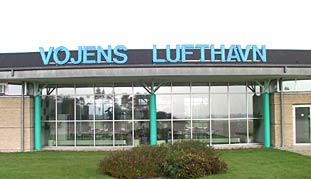
The Airport�s close location to the motorway (exit no. 68 north and 69 south), the railway station and Germany means easy and rational transport to and from the airport. A population of app. 300,000 people in Denmark and the nothern part of Germany can reach the Airport within 5 to 45 minutes by car. With its new airport building of 918 m2 for 1992 Vojens Airport is optimally equipped to influence the future of air transportation. Opening hours All weekdays from 6:30 to 23:30Weekends and public holidays - call for further arrangements Outside the opening hours � call for further arrangements 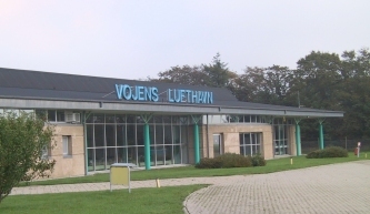 Vojens (Skrydstrup) Airport
Lilholtvej 8 Skrydstrup DK-6500 Vojens Telephone +45 7459 1654 Fax +45 7454 0006 E-mail airport at vojens dk WWW: Vojens (Skrydstrup) Airport Images and information placed above are from http://www.airport.vojens.dk/ We thank them for the data!
Runway 11R/29L9750 x 80 feet
|
|||||||||||||||||||||||||||||||||||||||||||||||||||||||||||||||||||||||||||||||||||||||||||||||||||||||||||||||||||||||||||||||||||||||||||||||||||||||||||||||||||||||||||||||||||||||||||||||||||||||||||||||||||||||||||||||||||||||||||||||||||||||||||||||||||||||
| Runway 11R | |
|---|---|
| Surface | PART CONCRETE, PART ASPHALT, OR PART BITUMEN-BOUND MACADAM. |
| True Heading | 105.0 |
| Latitude | 55.222697 55° 13' 21.71" N |
| Longitude | 9.243308 009° 14' 35.91" E |
| Elevation | 124.0 feet 38 meters |
| Slope | 0.2° |
| Landing Distance | 9750 feet 2972 meters |
| Takeoff Distance | 10233 feet 3119 meters |
| Overrun Length | 483 feet 147 meters |
| Overrun Surface | PART CONCRETE, PART ASPHALT, OR PART BITUMEN-BOUND MACADAM. |
| Lighting System | LIRL
PAPI |
| Runway 29L | |
|---|---|
| Surface | PART CONCRETE, PART ASPHALT, OR PART BITUMEN-BOUND MACADAM. |
| True Heading | 285.0 |
| Latitude | 55.215589 55° 12' 56.12" N |
| Longitude | 9.288319 009° 17' 17.95" E |
| Elevation | 139.0 feet 42 meters |
| Slope | -0.2° |
| Landing Distance | 9750 feet 2972 meters |
| Takeoff Distance | 10233 feet 3119 meters |
| Overrun Length | 483 feet 147 meters |
| Overrun Surface | PART CONCRETE, PART ASPHALT, OR PART BITUMEN-BOUND MACADAM. |
| Lighting System | LIRL
PAPI |
| Runway 11L | |
|---|---|
| Surface | PART CONCRETE, PART ASPHALT, OR PART BITUMEN-BOUND MACADAM. |
| True Heading | 105.0 |
| Latitude | 55.224600 55° 13' 28.56" N |
| Longitude | 9.243942 009° 14' 38.19" E |
| Elevation | 126.0 feet 38 meters |
| Slope | 0.2° |
| Landing Distance | 9863 feet 3006 meters |
| Takeoff Distance | 10597 feet 3230 meters |
| Overrun Length | 734 feet 224 meters |
| Overrun Surface | PART CONCRETE, PART ASPHALT, OR PART BITUMEN-BOUND MACADAM. |
| Lighting System | HIRL
J PAPI |
| Runway 29R | |
|---|---|
| Surface | PART CONCRETE, PART ASPHALT, OR PART BITUMEN-BOUND MACADAM. |
| True Heading | 285.0 |
| Latitude | 55.217408 55° 13' 02.67" N |
| Longitude | 9.289475 009° 17' 22.11" E |
| Elevation | 141.0 feet 43 meters |
| Slope | -0.2° |
| Landing Distance | 9863 feet 3006 meters |
| Takeoff Distance | 10597 feet 3230 meters |
| Overrun Length | 734 feet 224 meters |
| Overrun Surface | PART CONCRETE, PART ASPHALT, OR PART BITUMEN-BOUND MACADAM. |
| Lighting System | HIRL
J PAPI |
| SKRYDSTRUP | |||||
|---|---|---|---|---|---|
| Type | ID | Channel | Freq | Country | State |
| VORTAC | SKR | 041X | 110.4 | Denmark | - |
| Latitude | Longitude | Airport |
| 55.228939 55° 13' 44.18" N |
9.214058 009° 12' 50.61" E |
EKSP |
The content above was published at Airports-Worldwide.com in 2005.
We don't guarantee the information is fresh and accurate. The data may be wrong or outdated.
For more up-to-date information please refer to other sources.

 |
|
Copyright 2004-2024 © by Airports-Worldwide.com, Vyshenskoho st. 36, Lviv 79010, Ukraine Legal Disclaimer |
 Vojens (Skrydstrup) Airport is centrally located for Southern Jutland and Northern Germany.