 |
 |
|
||||
|
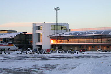
The airport is Scandinavia´s main airport, i.e. the transfer airport for air traffic between other parts of the world and the many national and regional airports in Scandinavia and the area south of the Baltic Sea. Copenhagen Airport functions as the hub for SAS and is thus one of the hubs in the Star Alliance. Star Alliance is a network of 15 international airlines that fly to a total of 772 airports in 133 countries. The airport is also the Scandinavian hub for DHL, the express air freight company. The airport is owned and operated by Copenhagen Airports A/S, a company listed on the Copenhagen Stock Exchange. There are about 22,000 employees in the many different companies that together provide the services that have made Copenhagen Airport one of the highest ranking in the world. In terms of passengers, the three largest airlines serving Copenhagen Airport are SAS, Maersk Air and Sterling European. Direct connections are available from Copenhagen Airport to a total of 127 destinations worldwide, seven of which are in Denmark, 20 are in other Scandinavian countries, 78 are in other European countries and 22 are intercontinental airports. Number of operations in 2004 (take-offs and landings): 272.518 Number of passengers in 2004: 19 million Cargo volumes in 2003: 335,731 tonnes Areas and runway systems The North Area, which contains the three passenger terminals, a railway station, a car park, a police station and other administrative functions, the Gate Gourmet catering facilities, the SAS Cargo Center and SAS's technical area, the last-mentioned with four large hangars. The East Area, which includes cargo terminals for DHL and SAS, the Veterinary and Customs Centre, forwarding agencies and the LSG Sky Chefs catering facilities. The South Area, in which technical bases for Maersk Air, My Travel, Sterling, Danish Air Transport and North Star are located. The West Area contains Naviair (air traffic mangement) and Copenhagen Airport’s technical maintenance facilities. The runway system consists of a main system (direction 22/04) with two parallel runways for take-offs and landings (3500 and 3300 metres long) and a 2800-metre cross-runway (direction 12/30). The runway used most frequently for landings (22L) contains equipment that makes landing possible even under conditions of extremely poor visibility (CAT 3). Runway 04 has equipment to permit landings under Cat 2 conditions, the other runways are what is called Cat1. The main runway system, with aircraft approaches and take-offs mainly taking place offshore, is used for about 95% of all flights. The maximum capacity of the runway system is 83 operations (take-offs and landings) per hour. Stand capacity IATA code - CPH ICAO code - EKCH
Tel: +45 3231 3231 E-mail: cph at cph dk E-mail: info-dept at cph dk WWW: Copenhagen Kastrup Int Airport Images and information placed above are from http://www.cph.dk/CPH/UK/MAIN/, http://www.scfotografi.dk/d1-035.htm We thank them for the data!
Runway 04R/22L10827 x 148 feet
|
||||||||||||||||||||||||||||||||||||||||||||||||||||||||||||||||||||||||||||||||||||||||||||||||||||||||||||||||||||||||||||||||||||||||||||||||||||||||||||||||||||||||||||||||||||||||||||||||||||||||||||||||||||||||||||||||||||||||||||||||||||||||||||||||||||||||||||||||||||||||||||||||||||||||||||||
| Runway 04R | |
|---|---|
| Surface | ASPHALT |
| True Heading | 041.0 |
| Latitude | 55.603100 55° 36' 11.16" N |
| Longitude | 12.633047 012° 37' 58.97" E |
| Elevation | 12.0 feet 4 meters |
| Slope | 0.0° |
| Landing Distance | 10827 feet 3300 meters |
| Takeoff Distance | 10827 feet 3300 meters |
| Lighting System | CL
HIRL BO PAPI |
| Runway 22L | |
|---|---|
| Surface | ASPHALT |
| True Heading | 221.0 |
| Latitude | 55.625411 55° 37' 31.48" N |
| Longitude | 12.667581 012° 40' 03.29" E |
| Elevation | 8.0 feet 2 meters |
| Slope | 0.0° |
| Landing Distance | 10827 feet 3300 meters |
| Takeoff Distance | 10827 feet 3300 meters |
| Lighting System | TDZL
CL HIRL A PAPI |
| Runway 04L | |
|---|---|
| Surface | ASPHALT |
| True Heading | 041.0 |
| Latitude | 55.592200 55° 35' 31.92" N |
| Longitude | 12.603536 012° 36' 12.73" E |
| Elevation | 13.0 feet 4 meters |
| Slope | 0.0° |
| Landing Distance | 11811 feet 3600 meters |
| Takeoff Distance | 11811 feet 3600 meters |
| Lighting System | TDZL
CL HIRL A PAPI |
| Runway 22R | |
|---|---|
| Surface | ASPHALT |
| True Heading | 221.0 |
| Latitude | 55.616528 55° 36' 59.50" N |
| Longitude | 12.641161 012° 38' 28.18" E |
| Elevation | 14.0 feet 4 meters |
| Slope | 0.0° |
| Landing Distance | 9844 feet 3000 meters |
| Takeoff Distance | 11811 feet 3600 meters |
| Displaced Threshold Length | 1967 feet 600 meters |
| Lighting System | CL
HIRL M PAPI |
| Runway 12 | |
|---|---|
| Surface | PART CONCRETE, PART ASPHALT, OR PART BITUMEN-BOUND MACADAM. |
| True Heading | 123.0 |
| Latitude | 55.627614 55° 37' 39.41" N |
| Longitude | 12.629747 012° 37' 47.09" E |
| Elevation | 13.0 feet 4 meters |
| Slope | 0.0° |
| Landing Distance | 7759 feet 2365 meters |
| Takeoff Distance | 10072 feet 3070 meters |
| Displaced Threshold Length | 2313 feet 705 meters |
| Lighting System | HIRL
M PAPI |
| Runway 30 | |
|---|---|
| Surface | PART CONCRETE, PART ASPHALT, OR PART BITUMEN-BOUND MACADAM. |
| True Heading | 303.0 |
| Latitude | 55.612525 55° 36' 45.09" N |
| Longitude | 12.670533 012° 40' 13.92" E |
| Elevation | 8.0 feet 2 meters |
| Slope | 0.0° |
| Landing Distance | 9186 feet 2800 meters |
| Takeoff Distance | 10072 feet 3070 meters |
| Displaced Threshold Length | 886 feet 270 meters |
| Lighting System | HIRL
BO PAPI |
| KASTRUP | |||||
|---|---|---|---|---|---|
| Type | ID | Channel | Freq | Country | State |
| VOR-DME | KAS | 072X | 112.5 | Denmark | - |
| Latitude | Longitude | Airport |
| 55.590519 55° 35' 25.87" N |
12.613603 012° 36' 48.97" E |
EKCH |
The content above was published at Airports-Worldwide.com in 2005.
We don't guarantee the information is fresh and accurate. The data may be wrong or outdated.
For more up-to-date information please refer to other sources.

 |
|
Copyright 2004-2025 © by Airports-Worldwide.com, Vyshenskoho st. 36, Lviv 79010, Ukraine Legal Disclaimer |
 Located just eight kilometres southeast of the Copenhagen city centre,
Copenhagen Airport is in Kastrup, a town on the island of Amager.
Located just eight kilometres southeast of the Copenhagen city centre,
Copenhagen Airport is in Kastrup, a town on the island of Amager.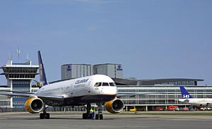 Address