 |
|
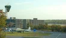
Rijeka Airport
Zračna luka Rijeka/Krk I. |
 |
| IATA: RJK – ICAO: LDRI |
| Summary |
| Airport type |
Public |
| Operator |
Rijeka Airport Ltd. |
| Serves |
Rijeka, Croatia |
| Location |
Omišalj, Croatia |
| Elevation AMSL |
278 ft / 85 m |
| Coordinates |
45°13′01″N 014°34′13″E / 45.21694°N 14.57028°E / 45.21694; 14.57028 |
| Website |
www.rijeka-airport.hr |
| Runways |
| Direction |
Length |
Surface |
| m |
ft |
| 14/32 |
2,500 |
8,202 |
Concrete/Asphalt |
| Croatian Aeronautical Information Publication |
Rijeka Airport (Croatian: Zračna luka Rijeka) (IATA: RJK, ICAO: LDRI) is the airport serving Rijeka, Croatia. It is located near the town of Omišalj on the island of Krk, 27 km from the Rijeka railway station.
Most of the traffic to and from the airport occurs during the summer months, when it is used by several European low-cost airlines flying tourists to the northern parts of the Croatian coast. During the winter months, most of the commercial flights using the airport are Air Berlin flights between Rijeka and Cologne/Bonn. The airport had 210,000 passengers in 2006.
Airlines and destinations
| Airlines |
Destinations |
| AirBaltic |
Riga [seasonal] |
| Air Berlin |
Cologne/Bonn, Stuttgart, Hannover [all seasonal] |
| Arkia Airlines |
Tel Aviv [seasonal] |
| Danube Wings |
Košice [seasonal] |
| Helvetic Airways |
Zürich [seasonal] |
| Norwegian Air Shuttle |
Oslo-Gardermoen [seasonal] |
The above content comes from Wikipedia and is published under free licenses – click here to read more.
| General Info
|
| Country |
Croatia
|
| ICAO ID |
LDRI
|
| Time |
UTC+1(+2DT)
|
| Latitude |
45.216889
45° 13' 00.80" N
|
| Longitude |
14.570267
014° 34' 12.96" E
|
| Elevation |
278 feet
85 meters
|
| Type |
Civil
|
| Magnetic Variation |
002° E (01/06)
|
| Operating Agency |
CIVIL GOVERNMENT, (LANDING FEES AND DIPLOMATIC CLEARANCE MAY BE REQUIRED)
|
| Alternate Name |
KRK ISLAND
|
| Near City |
Krk Island
|
| Operating Hours |
SEE REMARKS FOR OPERATING HOURS OR COMMUNICATIONS FOR POSSIBLE HOURS
|
| Daylight Saving Time |
Last Sunday in March to last Sunday in October
|
| Communications
|
TWR
By NOTAM.
|
119.0
|
APP
By NOTAM.
|
119.0
|
| Runways
|
| ID |
Dimensions |
Surface |
PCN |
ILS
|
| 14/32 |
8164 x 148 feet
2488 x 45 meters |
PART CONCRETE, PART ASPHALT, OR PART BITUMEN-BOUND MACADAM. |
045FAXT |
YES
|
| Navaids
|
| Type |
ID |
Name |
Channel |
Freq |
Distance From Field |
Bearing From Navaid
|
| VOR-DME |
RJK |
RIJEKA |
125X |
117.8 |
At Field |
-
|
| NDB |
KO |
KOZALA |
- |
438 |
8.8 NM |
143.4
|
| Supplies/Equipment
|
| Fuel |
Jet A, without icing inhibitor.
100/130 MIL Spec, low lead, aviation gasoline (BLUE)
|
| Remarks
|
| CAUTION |
Bird haz.
|
| FUEL |
(NC-100LL, A1)
|
| LGT |
Rwy 14 SALS O/S UFN.
|
| OPR HOURS |
Opr 0700-1500Z++, OT 24 hr PPR.
|
| RSTD |
24 hr PPR acft over 59' len.
|
The content above was published at Airports-Worldwide.com in 2010.
We don't guarantee the information is fresh and accurate. The data may be wrong or outdated.
For more up-to-date information please refer to other sources.
|
|


