|
|
Nanning Wuxu Airport
|
| IATA: NNG – ICAO: ZGNN
Nanning Wuxu
International Airport (China) |
| Summary |
| Airport type |
Public / Military |
| Operator |
Civil Aviation Administration of China |
| Serves |
Nanning |
| Elevation AMSL |
421 ft / 128 m |
| Coordinates |
22°36′29.76″N 108°10′20.79″E / 22.6082667°N 108.1724417°E / 22.6082667; 108.1724417 |
| Runways |
| Direction |
Length |
Surface |
| ft |
m |
| 05/23 |
10,499 |
3,200 |
Concrete |
Nanning Wuxu Airport (南宁吴圩机场) is an airport in Nanning, Guangxi, People’s Republic of China (IATA: NNG, ICAO: ZGNN).
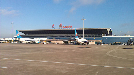
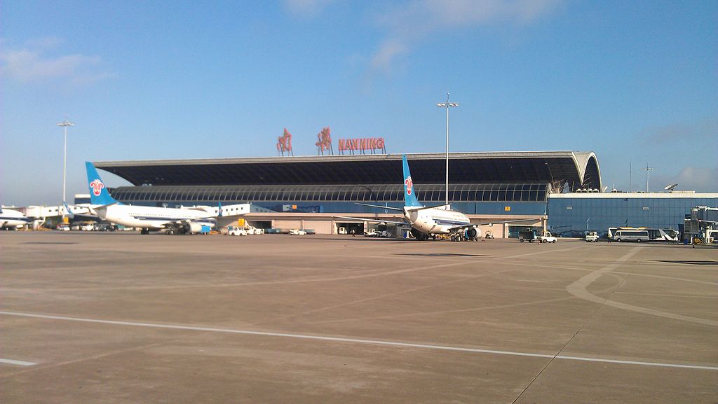
Nanning Wuxu International Airport
Click to enlarge
The airport is 32 km from the centre of the city, and the airport was built in 1962, with improvements made in 1990. With 106,000 m² of apron, 25,888 m² of terminal space and five jet bridges, the airport was designed to handle 2.5 million passengers traffic annually. After reaching 1 million passenger traffic in 2002, the number of passengers jumped to 2 million in 2006. In 2009, 4.52 million passengers used this airport.
History during World War II
During World War II, the airport was known as Nanning (Nan Ning) Airfield and was used by the United States Army Air Forces Fourteenth Air Force as part of the China Defensive Campaign (1942–1945). It was used primarily by reconnaissance units, which operated unarmed P-38 Lightning photo-recon aircraft that flew over Japanese-held territory and obtained intelligence used by combat units. Detachments of fighter and bomber squadrons also operated occasionally from the airfield, along with being a supply point for the 2d Combat Cargo Squadron, which air-dropped supplies and munitions to ground forces on the front lines. At the end of the war, the transports also hauled men, horses and mules to the airfield The Americans closed their facilities at the end of October 1945.
Airlines and destinations
| Airlines |
Destinations |
| Air China |
Beijing-Capital, Changsha, Chengdu, Hangzhou, Ho Chi Minh City |
| Air Macau |
Macau |
| China Eastern Airlines |
Kunming, Phnom Penh, Shanghai-Hongqiao, Vientiane, Yangon |
| China Southern Airlines |
Beijing-Capital, Changsha, Chongqing, Guangzhou, Guiyang, Haikou, Hong Kong, Kunming, Nanchang, Nanjing, Qingdao, Shanghai-Hongqiao, Shanghai-Pudong, Shantou, Shenzhen, Wuhan, Zhengzhou |
| China United Airlines |
Beijing-Nanyuan |
| Grand China Air |
Beijing-Capital |
| Grand China Express |
Guiyang, Haikou, Xi'an, Yinchuan |
| Hainan Airlines |
Changsha, Dalian, Bangkok-Suvarnabhumi |
| Juneyao Airlines |
Shanghai-Hongqiao |
| Shandong Airlines |
Hangzhou, Jinan, Qingdao, Wuhan, Xiamen, Zhuhai |
| Shanghai Airlines |
Shanghai-Hongqiao |
| Shenzhen Airlines |
Beijing-Capital, Chengdu, Guangzhou, Guilin, Guiyang, Hangzhou, Harbin, Hefei, Jakarta, Kuala Lumpur, Kunming, Qingdao, Nanjing, Shanghai-Hongqiao, Shenzhen, Shenyang, Singapore, Wuzhou, Xiamen, Zhengzhou |
| Spring Airlines |
Shanghai-Pudong |
| Sichuan Airlines |
Chengdu, Guilin ,Sanya |
| United Eagle Airlines |
Changsha, Chengdu, Ningbo, Wenzhou, Wuhan |
| Xiamen Airlines |
Fuzhou, Hangzhou, Shenzhen, Xiamen |
Ground transportation
Beside parking facilities and taxis, two airport bus lines connect the airport with the city center: Line No. 1 serving the Chaoyang Road Airline Ticket Office (near Nanning Railway Station) and Line No. 2 serving Wuxiang Square.
Extension
The new terminal under construction is scheduled to be finished in 2012. Meanwhile, with passenger traffic almost double the designed capacity and cargo traffic 3 times over the designed capacity, a temporary solution is urgently needed before the complete of the new terminal.
The above content comes from Wikipedia and is published under free licenses – click here to read more.
| General Info
|
| Country |
China
|
| ICAO ID |
ZGNN
|
| Time |
UTC+8
|
| Latitude |
22.608267
22° 36' 29.76" N
|
| Longitude |
108.172442
108° 10' 20.79" E
|
| Elevation |
421 feet
128 meters
|
| Type |
Joint (Civil and Military)
|
| Magnetic Variation |
001° W (01/06)
|
| Operating Agency |
MILITARY - CIVIL JOINT USE AIRPORT
|
| Alternate Name |
NANNING
|
| Near City |
Nanning
|
| Operating Hours |
SEE REMARKS FOR OPERATING HOURS OR COMMUNICATIONS FOR POSSIBLE HOURS
|
| Communications
|
NANNING TWR
Opr HO.
|
130.0
118.2
|
NANNING GND
Opr HO.
|
121.75
|
| Runways
|
| ID |
Dimensions |
Surface |
PCN |
ILS
|
| 05/23 |
8858 x 148 feet
2700 x 45 meters |
CONCRETE. |
049RBXT |
YES
|
| Navaids
|
| Type |
ID |
Name |
Channel |
Freq |
Distance From Field |
Bearing From Navaid
|
| VOR-DME |
NNG |
NANNING |
092X |
114.5 |
1.7 NM |
233.4
|
| Supplies/Equipment
|
| Fuel |
Jet fuel avaiable but type is unknown.
|
| Remarks
|
| CSTMS/AG/IMG |
Avbl.
|
| FUEL |
(NC-J)
|
| OPR HOURS |
Opr HS or O/R.
|
The content above was published at Airports-Worldwide.com in 2010.
We don't guarantee the information is fresh and accurate. The data may be wrong or outdated.
For more up-to-date information please refer to other sources.
|
|