 |
|
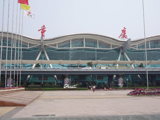
Chongqing Jiangbei International Airport
重庆江北国际机场
Chóngqìng Jiāngběi Guójì Jīchǎng |
 |
| IATA: CKG – ICAO: ZUCK |
| Summary |
| Airport type |
Public |
| Serves |
Chongqing |
| Location |
Yubei District, Chongqing |
| Hub for |
Sichuan Airlines |
| Elevation AMSL |
416 m / 1,365 ft |
| Coordinates |
29°43′09″N 106°38′30″E / 29.71917°N 106.64167°E / 29.71917; 106.64167 |
| Runways |
| Direction |
Length |
Surface |
| m |
ft |
| 02/20 |
3,200 |
10,499 |
Concrete |
Chongqing Jiangbei International Airport (Simplified Chinese: 重庆江北国际机场, Traditional Chinese: 重慶江北國際機場, Pinyin: Chóngqìng Jiāngběi Guójì Jīchǎng) (IATA: CKG, ICAO: ZUCK) is an airport located in the Yubei District of Chongqing, People's Republic of China. It is located 21km away from the city-centre of Chongqing and serves as an important hub for south-western China. In 2007, Jiangbei airport handled 10,355,730 passengers, and ranked number 10 of all airports in China. It is a hub for Chongqing Airlines, Sichuan Airlines and later China West Air when it begins operations and Shenzhen Airlines when it opens a hub at the airport. It is also a focus city for Air China. The first and second phase of the airport came into operation in January 1990 and December 2004 respectively. Currently Jiangbei airport has two terminals with one serving domestic flights and the other mainly international flights. Its domestic terminal is capable of handling 7 million passengers while its international terminal is able to handle more than 1 million passengers annually. A third terminal is currently in the planning stage with a second and third runway construction due to commence shortly.
In terms of passenger traffic, Chongqing airport was the 10th busiest airport nationwide in 2009, handling 14,083,045 people. Also, the airport was the 11th busiest airport by cargo traffic and by traffic movements in China.
Airlines and destinations
Note: Flights to Hong Kong and Taiwan are treated as international flights.
| Airlines |
Destinations |
| Air China |
Bangkok-Suvaranbhumi, Beijing-Capital, Changsha, Guangzhou, Guilin, Hangzhou, Hefei, Hong Kong, Kunming, Lanzhou, Lhasa, Nanchang, Nanjing, Qingdao, Sanya, Shanghai-Pudong, Seoul-Incheon, Shenzhen, Taipei-Taoyuan, Taiyuan, Tokyo-Narita, Zhengzhou |
| Asiana Airlines |
Seoul-Incheon |
| China Eastern Airlines |
Hefei, Jinjiang, Kunming, Nanjing, Shanghai-Pudong, Shijiazhuang, Taiyuan, Wenzhou, Wuhan, Wuxi, Xi'an |
| China Southern Airlines |
Changsha, Dalian, Guangzhou, Guilin, Guiyang, Kunming, Lhasa, Nanning, Sanya, Shenyang, Shenzhen, Urumqi, Wuhan, Yiwu, Zhengzhou |
| China United Airlines |
Beijing-Nanyuan |
| Chongqing Airlines |
Beijing-Capital, Changsha,Fuzhou,Guangzhou, Kunming,Nanchang,Sanya, Shanghai-Pudong |
| Deer Air |
Guangzhou |
| Dragonair |
Hong Kong |
| Hainan Airlines |
Beijing-Capital, Changsha, Guangyuan, Guangzhou, Haikou, Lanzhou, Nanning, Shenzhen, Xi'an, Zhengzhou |
| Juneyao Airlines |
Shanghai-Hongqiao, Shanghai-Pudong |
| Shandong Airlines |
Jinan, Kunming, Qingdao |
| Shanghai Airlines |
Bangkok-Suvarnabhumi, Shanghai-Pudong |
| Shenzhen Airlines |
Changsha, Changzhou, Guiyang, Lhasa, Shenzhen, Zhengzhou |
| Sichuan Airlines |
Beijing-Capital, Changsha, Dalian, Guangzhou, Guilin, Guiyang, Haikou, Hangzhou, Harbin, Hefei, Jinan, Jiuzhaigou, Kunming, Lanzhou, Lhasa, Lijiang City, Nanjing, Nanning, Ningbo, Panzhihua, Sanya, Shanghai-Pudong, Shenyang, Shenzhen, Taipei-Songshan, Tianjin, Urumqi, Wenzhou, Wuhan, Wuxi, Xi'an, Xiamen, Xining, Yichang, Zhangjiajie, Zhengzhou |
| SilkAir |
Singapore |
| Spring Airlines |
Shanghai-Pudong |
| Uni Air |
Taipei-Taoyuan |
| United Eagle Airlines |
Beihai |
| Xiamen Airlines |
Changsha, Guilin, Hangzhou, Nanchang |
The above content comes from Wikipedia and is published under free licenses – click here to read more.
| General Info
|
| Country |
China
|
| ICAO ID |
ZUCK
|
| Time |
UTC+8
|
| Latitude |
29.719217
29° 43' 09.18" N
|
| Longitude |
106.641678
106° 38' 30.04" E
|
| Elevation |
1365 feet
416 meters
|
| Type |
Civil
|
| Magnetic Variation |
002° W (01/06)
|
| Operating Agency |
CIVIL GOVERNMENT, (LANDING FEES AND DIPLOMATIC CLEARANCE MAY BE REQUIRED)
|
| Alternate Name |
CHONGQING
|
| Near City |
Chongqing
|
| Communications
|
CHONGQING TWR
Opr HO.
|
118.2
130.0
|
CHONGQING GND
Opr HO.
|
121.75
|
ATIS
Opr HO.
|
126.4
|
CHONGQING APP
Opr HO.
|
125.2
119.55
|
| Runways
|
| ID |
Dimensions |
Surface |
PCN |
ILS
|
| 02/20 |
10499 x 148 feet
3200 x 45 meters |
CONCRETE. |
052RBWT |
YES
|
| Navaids
|
| Type |
ID |
Name |
Channel |
Freq |
Distance From Field |
Bearing From Navaid
|
| VOR-DME |
CKG |
CHONGQING |
108X |
116.1 |
At Field |
-
|
| NDB |
WX |
CHANGSHENGQIAO |
- |
306 |
9.9 NM |
355.5
|
| Supplies/Equipment
|
| Fuel |
Jet fuel avaiable but type is unknown.
|
| Remarks
|
| CSTMS/AG/IMG |
Avbl.
|
| FUEL |
(NC-J)
|
| RSTD |
SSR transponder rqr for tkof and ldg. 180 on twy proh.
|
The content above was published at Airports-Worldwide.com in 2010.
We don't guarantee the information is fresh and accurate. The data may be wrong or outdated.
For more up-to-date information please refer to other sources.
|
|


