|
|
Mataveri International Airport |
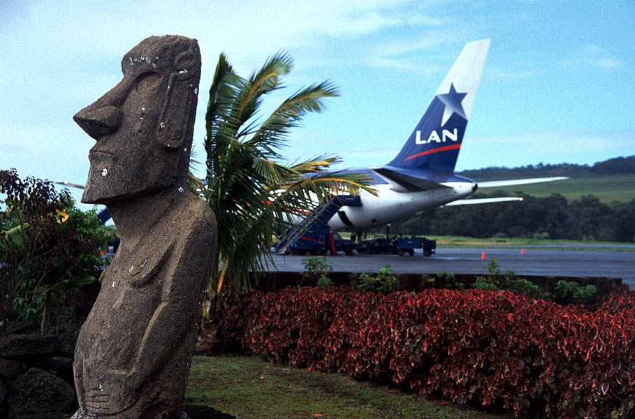
Mataveri International Airport or Isla de Pascua Airport (IATA: IPC, ICAO: SCIP) is at Hanga Roa on Rapa Nui (Easter Island) (Isla de Pascua in Spanish). The most remote airport in the world (defined as distance to another airport), it is 2,336 miles (3,759 km) from Santiago, Chile (SCL) which has scheduled flights to it on the Chilean carrier LATAM Chile. The runway starts just inland from the island’s southeast coast at Mataveri, and nearly reaches the west coast, almost separating the mountain of Rano Kau from the rest of the island. The airport is the main point of entry for thousands of tourists who come to Easter Island to see its Moai statues. It has a transit lounge used by passengers continuing to or returning from Papeete, Tahiti, which is also serviced by LATAM.
|
Mataveri International Airport
Isla de Pascua Airport
|
|
|
|
| Summary |
| Airport type |
Military/Public |
| Operator |
FACH – Fuerza Aérea de Chile (Chilean Air Force) |
| Location |
Mataveri |
| Elevation AMSL |
227 ft / 69 m |
| Coordinates |
27°09′53″S
109°25′18″W |
| Website |
mataverinternational.com |
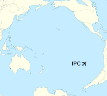
| Map |
Location of airport in Pacific Ocean
|
| Runways |
| Direction |
Length |
Surface |
| m |
ft |
| 10/28 |
3,305 |
10,843 |
Asphalt |
|
History
Scheduled services from the Chilean mainland started in 1967 with a monthly Douglas DC-6B propliner flight operated by LAN-Chile that took nine hours, using a runway extended and paved for the use as a U.S. base. In 1970, services were upgraded with weekly Boeing 707-320 nonstop jet service to Santiago, Chile and Papeete, Tahiti (PPT). Nonstop service to Papeete had been added earlier during the late 1960s using a DC-6B and the frequency then doubled to twice-weekly with LAN-Chile providing direct connecting 707 service once a week between Easter Island and Frankfurt, Paris and Madrid in Europe via its Santiago hub. By 1975, LAN-Chile had extended its Tahiti route flown once a week with a 707 to Nadi, Fiji (NAN). LAN-Chile then replaced its Boeing 707 flights with Boeing 767-200ER jet service and in 1993 was operating twice weekly round trip flights on a routing of Santiago (SCL) – Easter Island (IPC) – Papeete (PPT). The airline later operated Airbus A340 and Boeing 767-300ER wide body jetliners into the airport.
The airport’s single runway is 3,318 m (10,885 ft) long. The airport was once designated as an abort site for the U.S. Space Shuttle when polar orbital flights from Vandenberg Air Force Base in southern California were planned with this space launch activity then subsequently being cancelled. The project undertaken by NASA to lengthen the runway was completed in 1987 and enabled wide-bodied jets to use the airport, which further boosted tourism to the island.
Due to the lack of diversion airports between PPT (Tahiti) and South America except for IPC, the Chilean CAA prohibits more than one aircraft from the vicinity of IPC. Once an aircraft flying from South America is more than at the halfway point between South America and IPC, no other aircraft can be closer than the halfway point until the first aircraft successfully lands at IPC. This is because if an aircraft should have an accident that obstructs or closes the runway, other aircraft cannot land at IPC and would have to turn back.
The Isla de Pascua VOR-DME (Ident: IPA) and non-directional beacon (Ident: IPA) are located on the field. Also, an Instrument Landing System(ILS) is available for precision approaches for runway 10 (roughly west-east bound)
There is a hill adjacent to the eastern end of the runway. Approach and departures to either end of the runway are over the water.
Airlines and destinations
| Destinations |
| LATAM Chile |
Papeete, Santiago de Chile |
LATAM Chile currently operates Boeing 787-9 and Boeing 787-8 aircraft to the island on its scheduled services.

The above content comes from Wikipedia and is published under free licenses – click here to read more.
| General Info
|
| Country |
Chile
|
| ICAO ID |
SCIP
|
| Time |
UTC-6(-5DT)
|
| Latitude |
-27.164792
27° 09' 53.25" S
|
| Longitude |
-109.421831
109° 25' 18.59" W
|
| Elevation |
227 feet
69 meters
|
| Type |
Joint (Civil and Military)
|
| Magnetic Variation |
015° E (01/06)
|
| Beacon |
Yes
|
| Operating Agency |
MILITARY - CIVIL JOINT USE AIRPORT
|
| Near City |
Isla de Pascua
|
| Island Group |
EASTER I
|
| Operating Hours |
SEE REMARKS FOR OPERATING HOURS OR COMMUNICATIONS FOR POSSIBLE HOURS
|
| International Clearance Status |
Airport of Entry
|
| Communications
|
| PASCUA TWR |
118.1
121.9
|
| PASCUA RDO |
127.3
3467
4669
5643
6649
|
| PASCUA APP |
127.3
118.1
121.5
|
| Runways
|
| ID |
Dimensions |
Surface |
PCN |
ILS
|
| 10/28 |
10885 x 145 feet
3318 x 44 meters |
ASPHALT |
065FCWT |
YES
|
| Navaids
|
| Type |
ID |
Name |
Channel |
Freq |
Distance From Field |
Bearing From Navaid
|
| VOR-DME |
IPA |
ISLA DE PASCUA |
118X |
117.1 |
At Field |
-
|
| NDB |
IPA |
ISLA DE PASCUA |
- |
280 |
At Field |
-
|
| Supplies/Equipment
|
| Fuel |
Jet A1, without icing nhibitor.
100/130 MIL Spec, low lead, aviation gasoline (BLUE)
|
| Remarks
|
| CAUTION |
Bird haz. First turning bay thld Rwy 28 unsvc. Ant lctd 4429 ' N rwy cntrline hgt 121' unlgtd.
|
| FUEL |
A1 cash only, 48 hr PN. 100LL avbl with 6 month PN. (NC-100LL, A1)
|
| LGT |
PAPI Rwy 10 GS 2.5 . PAPI Rwy 28 GS 2.8 .
|
| OPR HOURS |
Opr O/R SR-SS.
|
The content above was published at Airports-Worldwide.com in 2020.
We don't guarantee the information is fresh and accurate. The data may be wrong or outdated.
For more up-to-date information please refer to other sources.
|
|