|
|
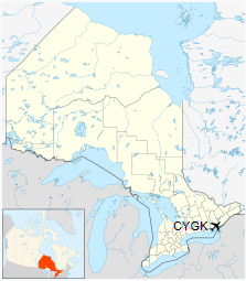
Kingston Airport (IATA: YGK, ICAO: CYGK), also known as Norman Rogers Airport, is an airport located 4.3 nautical miles (8.0 km; 4.9 mi) west of the core of Kingston, Ontario, Canada.
The airport is named after former MP Norman McLeod Rogers (Kingston City 1935–1940), Minister of Labour and then National Defence in Prime Minister William Lyon Mackenzie King’s cabinet. Rogers died in a plane crash on June 10, 1940 while flying from Ottawa to Toronto for a speaking engagement.
|
Kingston Airport
|
|
- IATA: YGK
- ICAO: CYGK
- WMO: 71620
|
| Summary |
| Airport type |
Public |
| Operator |
City of Kingston |
| Location |
Kingston, Ontario |
| Time zone |
EST (UTC−05:00) |
| • Summer (DST) |
EDT (UTC−04:00) |
| Elevation AMSL |
303 ft / 92 m |
| Coordinates |
44°13′35″N
076°35′48″W |
| Website |
www.cityofkingston.ca |
| Map |
|
|
| Runways |
| Direction |
Length |
Surface |
| ft |
m |
| 01/19 |
6,001 |
1,829 |
Asphalt |
| 07/25 |
3,909 |
1,191 |
Asphalt |
|
| Statistics (2010) |
| Aircraft movements |
37,876 |
|
History
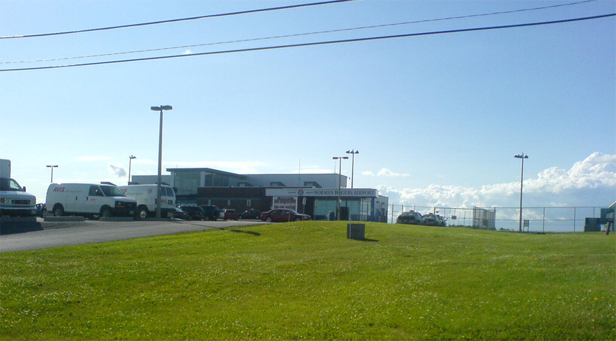
Norman Rogers Airport terminal
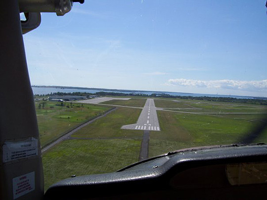
On approach to runway 25 in a Cessna C-150
Before 1940, Kingston was served only by the Kingston Airfield, a grass strip just north of the city’s downtown, which closed in 1942. In 1940, during the Second World War, an airfield was built to the west of Kingston to serve as a training station for the Royal Air Force’s No. 31 Service Flying Training School (SFTS). The school provided advanced flight training in Battle and Harvardaircraft. In 1942 the school became part of the British Commonwealth Air Training Plan (BCATP). The BCATP’s No. 14 Service Flying Training School moved to Kingston in 1944 and merged with the RAF school. No. 14 SFTS used Harvards, Yales and Ansons. A decommissioned yellow Harvard aircraft now stands on a pedestal near the airport entrance to commemorate the airport’s wartime role. The airport was transferred to city control in 1972.
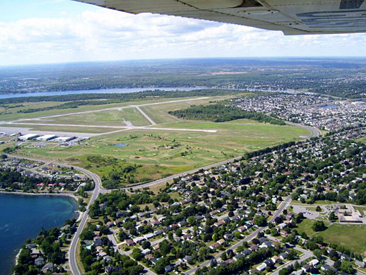
The airport’s runway outline displays the classic BCATP triangle pattern. The airport was built with six 2,500 ft (760 m) runways; however, this was reduced to three, as they were all parallel runways. One can still see where some parts of the parallel runways were from the air. Later, runway 01/19 was extended northwards to a length of 5,000 ft (1,500 m) to handle larger aircraft, and it is planned to be extended to 6,000 ft (1,800 m) (the prevailing wind is from the south off Lake Ontario). Runway 07/25 was extended northeastwards to a length of nearly 4,000 ft (1,200 m), with no plans to extend it, due to the requirements for certified airports on runways over a certain length. The remaining runway, 12/30, was decommissioned in 2003 and converted to a taxiway.
Airlines and destinations
| Destinations |
| Air Canada Express |
Toronto–Pearson |
Air cargo carriers and destinations
| Destinations |
| SkyLink Express |
Hamilton |
Frequencies
Kingston Airport services three frequencies: ATIS (135.550 MHz) and radio (122.500 MHz). There is also guidance for private aircraft needing fuel or parking on Kingston Flying Club Advisory (122.800 MHz)
Operations
Kingston is a mandatory frequency airport with an operating flight service station. The airport also supports a large amount of general aviation traffic, including flight training and general recreational flying. As one of the only public airports to offer an ILS approach along the corridor between Montréal–Trudeau and Toronto–Pearson|Toronto (along with Ottawa Macdonald–Cartier), the Kingston airport is an important alternate during poor weather conditions.
Kingston Airport from the air
There are two Flight Training Units located on the field. Kingston Flying Club, a flight school and charter operation is located in hanger 5 and Fly Kingston/Fly Canadian is located in hanger 4. The airport is classified as an airport of entry by Nav Canadaand is staffed by the Canada Border Services Agency. CBSA officers at this airport can handle aircraft with no more than 30 passengers.
The above content comes from Wikipedia and is published under free licenses – click here to read more.
| General
Info |
| Country |
Canada
|
| ICAO ID |
CYGK |
| Time |
UTC-5(-4DT)
|
| Latitude |
44.225277
44° 13' 31.00" N |
| Longitude |
-76.596944
076° 35' 49.00" W |
| Elevation |
305 feet
93 meters |
| Type |
Civil
|
| Magnetic
Variation |
012° W
(01/06) |
| Beacon |
Yes |
| Operating
Agency |
CIVIL
GOVERNMENT, (LANDING FEES AND DIPLOMATIC CLEARANCE MAY BE REQUIRED)
|
| Operating
Hours |
SEE REMARKS
FOR OPERATING HOURS OR COMMUNICATIONS FOR POSSIBLE HOURS |
| International
Clearance Status |
Airport
of Entry |
| Daylight
Saving Time |
Second
Sunday in March at 0200 to first Sunday in November at 0200 local
time (Exception Arizona and that portion of Indiana in the Eastern
Time Zone) |
| Communications
|
RDO
Opr 1115-0400Z++, OT ctc OTTAWA TRML 135.05 398.4.- |
122.5
238.3 |
CTAF
Opr 0400-1115Z++. |
122.5
|
MF
Opr 1115-0400Z++. |
122.5
|
| Communications
Remarks |
|
| RDO |
Emerg
only C613-389-7558. (APP/DEP svc) |
| Runways
|
| ID |
Dimensions |
Surface |
PCN |
ILS
|
| 01/19
|
5000 x
100 feet
1524 x 30 meters |
ASPHALT |
- |
NO |
| 07/25
|
3933 x
100 feet
1199 x 30 meters |
ASPHALT |
- |
NO |
| Navaids
|
| Type |
ID |
Name |
Channel |
Freq |
Distance
From Field |
Bearing
From Navaid |
| NDB |
YGK |
KINGSTON |
- |
263 |
4.3 NM |
188.1
|
| Supplies/Equipment
|
| Fuel |
Jet A1,
without icing nhibitor.
80/87 octane gasoline, leaded, MIL-L-5572F (RED)
100/130 MIL Spec, low lead, aviation gasoline (BLUE) |
| Other
Fluids |
DE-ICE,
Anti-icing/De-icing/Defrosting Fluid (MIL A 8243) |
| JASU |
CE15
DC 22-35v, 500 amp continuous 1100 amp intermittent |
| Remarks
|
| CAUTION |
Crane
106' AGL 355' MSL lctd .5 NM N thld Rwy 19 cont dly Apr-Nov. Wildlife
haz. |
| FLUID |
De-Ice
|
| FUEL |
A1+ (Central
Sky Svc, Imperial Oil/ESSO, C613-389-9300. Avbl 1100-0200Z++ Mon-Fri;
1300-0200Z++ Sat-Sun, OT call out fee C613-389-9300.) (NC-100LL, A1)
|
| JASU |
1(CE15)
|
| LGT |
ACTIVATE-ALS,
HIRL, PAPI Rwy 01-19 and LIRL, PAPI Rwy 07-25- CTAF. PAPI Rwy 01-19
12 lgt unit for acft with eye-to-wheel height up to 25' and Rwy 07-25
10'. |
| MISC |
Due to
slope Rwy 01-19 acft on rwy ends may not be visible to pilots at oppositeends
of rwy. Ltd win maint hr Mon-Fri exc hol, OT 3 hr PN. Fee will be
levied. |
| OPR HOURS |
Attended
ltd hr, C613-389-6404. |
| RSTD |
Prk area
N of main apn rstd to acft less than 12,500 lb. |
The content above was published at Airports-Worldwide.com in 2018.
We don't guarantee the information is fresh and accurate. The data may be wrong or outdated.
For more up-to-date information please refer to other sources.
|
|