|
|
Red Deer Regional Airport |
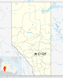
Red Deer Regional Airport, (IATA: YQF, ICAO: CYQF), is located 6 nautical miles (11 km; 6.9 mi) south southwest of Red Deer, Alberta, Canada. The airport is mostly general aviation and charter service.
In October 2015, Red Deer Regional announced it was to undergo a $9.5 million expansion, including a 2,000 ft (610 m) extension of runway 16/34 (now 17/35), from 5,528 ft (1,685 m) to 7,528 ft (2,295 m). Construction began in April 2016, and was completed on September 16, 2016. However, the extension, which measured 7,500 ft (2,300 m), was not posted in the Canada Flight Supplement until the edition dated 0901Z 2 March 2017 to 0901Z 27 April 2017. This allowed the airport to accommodate larger aircraft. Canada Jetlines is the first airline expected to take advantage of this, with plans to begin either Boeing 737 Max or Airbus A320 service to Abbotsford by their third projected growth period.
| Red Deer Regional Airport |
|
- IATA: YQF
- ICAO: CYQF
- WMO: 71878
|
| Summary |
| Airport type |
Public |
| Owner/Operator |
Red Deer Regional Airport Authority |
| Serves |
Central Alberta |
| Location |
Red Deer County, near Red Deer, Alberta |
| Time zone |
MST (UTC-07:00) |
| Summer (DST) |
MDT (UTC-06:00) |
| Elevation AMSL |
2,968 ft / 905 m |
| Coordinates |
52°11'06″N
113°53'40″W |
| Website |
http://www.flyreddeer.com |
| Map |
|
|
| Runways |
| Direction |
Length |
Surface |
| ft |
m |
| 12/30 |
3,454 |
1,053 |
Asphalt |
| 17/35 |
7,500 |
2,286 |
Asphalt |
|
| Statistics (2016) |
| Aircraft movements |
42,134 |
|
History
During World War II, the airport was RCAF Station Penhold. The airbase was home to the Royal Air Force, No. 36 Service Flying Training School (SFTS). After the war the base was closed. The base was reopened in 1952 to train NATO pilots. The airfield side of the base was closed in 1965, and the City of Red Deer took over operation of the airport in 1966. The non-airport side of the base was renamed CFB Penhold in 1966 and remained a base until 1990 when it was made a detachment of CFB Edmonton. The base hosted Cadet Summer Training from the Second World War until 2014. The former base was closed in 1994 and the former Married Quarters were renamed from Mynarski Park to Springbrook in 1995. The former military base was converted into an industrial park known as Harvard Park.
The above content comes from Wikipedia and is published under free licenses – click here to read more.
| General Info
|
| Country |
Canada
|
| ICAO ID |
CYQF
|
| Latitude |
52.182222
52° 10' 56.00" N
|
| Longitude |
-113.894444
113° 53' 40.00" W
|
| Elevation |
2968 feet
905 meters
|
| Type |
Civil
|
| Magnetic Variation |
016° E (01/06)
|
| Beacon |
Yes
|
| Operating Agency |
MUNICIPAL
|
| Daylight Saving Time |
Second Sunday in March
at 0200 to first Sunday in November at 0200 local time (Exception
Arizona and that portion of Indiana in the Eastern Time Zone) |
| Communications
|
| EDMONTON RDO |
122.5
126.7
|
| RDO |
118.5
324.8
|
| EDMONTON CNTR |
132.85
239.0
|
| ATIS |
124.0
|
| MF RED DEER RDO |
118.5
|
| Communications Remarks |
|
| FSS |
(Emerg only C403-886-4547)
|
| Runways
|
| ID |
Dimensions |
Surface |
PCN |
ILS
|
| 11/29 |
3449 x 100 feet
1051 x 30 meters |
ASPHALT |
- |
NO
|
| 16/34 |
5528 x 98 feet
1685 x 30 meters |
ASPHALT |
- |
NO |
| Navaids
|
| Type |
ID |
Name |
Channel |
Freq |
Distance From Field |
Bearing From Navaid
|
| NDB |
YQF |
RED DEER |
- |
320 |
3.2 NM |
346.0
|
| DME |
6G |
RED DEER |
053X |
- |
At Field |
- |
| Supplies/Equipment
|
| Fuel |
JP-4, Wide cut turbine
fuel MIL Spec T-5624
100/130 octane gasoline, leaded, MIL-L-5572F (GREEN) |
The content above was published at Airports-Worldwide.com in 2018.
We don't guarantee the information is fresh and accurate. The data may be wrong or outdated.
For more up-to-date information please refer to other sources.
|
|