|
|
Claresholm Industrial Airport |
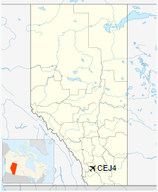
Claresholm Industrial Airport (formerly known as RCAF Station Claresholm) (TC LID: CEJ4) is located 2.5 nautical miles (4.6 km; 2.9 mi) south southwest of Claresholm, Alberta, Canada.
The airport opened in 1941 as RCAF Station Claresholm as part of the British Commonwealth Air Training Plan and closed in 1945. In 1951 it was reopened as a NATO training centre and closed again in 1958 when the centre was moved. The airport was later reopened as Claresholm Industrial Airport.
Claresholm’s single operating runway is one of the RCAF station’s three runways. Claresholm was built in the typical triangular pattern of three runways in order to accommodate a wide range of wind directions. The other two original runways are now abandoned but in current aerial photography these runways and accompanying taxiways appear to be in at least fair condition unlike those at the nearby Fort Macleod Airport.
| Claresholm Industrial Airport |
- IATA: none
- ICAO: none
- TC LID: CEJ4
|
| Summary |
| Airport type |
Public |
| Operator |
Town of Claresholm |
| Location |
Municipal District of Willow Creek No. 26, near Claresholm, Alberta |
| Time zone |
MST (UTC−07:00) |
| • Summer (DST) |
MDT (UTC−06:00) |
| Elevation AMSL |
3,325 ft / 1,013 m |
| Coordinates |
50°00′17″N
113°37′48″W |
| Map |
|
|
| Runways |
| Direction |
Length |
Surface |
| ft |
m |
| 03/21 |
3,100 |
945 |
Asphalt |
|
The above content comes from Wikipedia and is published under free licenses – click here to read more.
| General Info
|
| Country |
Canada
|
| Latitude |
50.004722
50° 00' 17.00" N
|
| Longitude |
-113.630000
113° 37' 48.00" W
|
| Elevation |
3325 feet
1013 meters
|
| Magnetic Variation |
015° E (01/06)
|
| Beacon |
Yes
|
| Operating Agency |
MUNICIPAL
|
| Daylight Saving Time |
Second Sunday in March
at 0200 to first Sunday in November at 0200 local time (Exception
Arizona and that portion of Indiana in the Eastern Time Zone) |
| Communications
|
| CTAF/UNICOM |
123.0 |
| Runways
|
ID
|
Dimensions |
Surface |
PCN |
ILS
|
| 03/21 |
3100 x 100 feet
945 x 30 meters |
ASPHALT |
- |
NO
|
09/27
CLOSED |
3100 x 100 feet
945 x 30 meters |
ASPHALT |
- |
NO
|
14/32
CLOSED
CLOSED |
3100 x 100 feet
945 x 30 meters |
ASPHALT |
- |
NO |
| Navaids
|
| Type |
ID |
Name |
Channel |
Freq |
Distance From Field |
Bearing From Navaid
|
| NDB |
Z7 |
CLARESHOLM |
- |
408 |
At Field |
- |
| Supplies/Equipment
|
| Fuel |
100/130 octane gasoline,
leaded, MIL-L-5572F (GREEN)
80/87 octane gasoline, leaded, MIL-L-5572F (RED) |
The content above was published at Airports-Worldwide.com in 2018.
We don't guarantee the information is fresh and accurate. The data may be wrong or outdated.
For more up-to-date information please refer to other sources.
|
|