|
|
Bhamo Airport
(Banmaw Airport) |
IATA: BMO – ICAO: VYBM
Bhamo (Banmaw)
Location of airport in Burma
|
| Summary |
| Airport type |
Public |
| Operator |
Government |
| Serves |
Bhamo (Banmaw), Myanmar (Burma) |
| Elevation AMSL |
370 ft / 113 m |
| Coordinates |
24°16′15″N 097°14′49″E / 24.27083°N 97.24694°E / 24.27083; 97.24694 |
| Runways |
| Direction |
Length |
Surface |
| m |
ft |
| 15/33 |
1,677 |
5,502 |
Bitumen |
| Sources: |
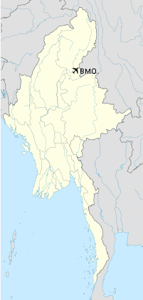
Bhamo Airport (IATA: BMO, ICAO: VYBM) is an airport serving Bhamo (Banmaw), a city in the Kachin State in northern Myanmar (Burma). It is also known as Banmaw Airport.
History
Built as a Japanese Air Force base in 1942, the airport was attacked numerous times by Allied forces before being seized in May 1945. It was repaired by the 1891st Engineer Aviation Battalion then was used as a combat resupply and casualty evacuation airfield by Tenth Air Force, which moved elements of the 1st Combat Cargo Group to the field. It was also used as a communications relay station as well as a base for forward air controllers (51st Fighter Control Squadron). It was closed at the end of September 1945.
Facilities
The airport resides at an elevation of 370 feet (113 m) above mean sea level. It has 1 runway designated 15/33 with a bituminous surface measuring 1,677 by 31 metres (5,502 × 102 ft).
Airlines and destinations
- Myanma Airways (Mandalay)
The above content comes from Wikipedia and is published under free licenses – click here to read more.
| General Info
|
| Country |
Burma
|
| ICAO ID |
VYBM
|
| Time |
UTC+6:30
|
| Latitude |
24.269033
24° 16' 08.52" N
|
| Longitude |
97.246153
097° 14' 46.15" E
|
| Elevation |
370 feet
113 meters
|
| Magnetic Variation |
000° W (05/06)
|
| Operating Agency |
CIVIL GOVERNMENT, (LANDING FEES AND DIPLOMATIC CLEARANCE MAY BE REQUIRED)
|
| Runways
|
| ID |
Dimensions |
Surface |
PCN |
ILS
|
| 15/33 |
5502 x 102 feet
1677 x 31 meters |
BITUMINOUS, TAR OR ASPHALT MIXED IN PLACE, OILED. |
- |
NO
|
| Navaids
|
| Type |
ID |
Name |
Channel |
Freq |
Distance From Field |
Bearing From Navaid
|
| NDB |
BM |
BANMAW |
- |
320 |
At Field |
-
|
| Remarks
|
| CSTMS/IMG |
Avbl O/R.
|
| MISC |
Ldg fees.
|
| OPR HOURS |
Opr HO.
|
The content above was published at Airports-Worldwide.com in 2010.
We don't guarantee the information is fresh and accurate. The data may be wrong or outdated.
For more up-to-date information please refer to other sources.
|
|