|
|
Belém International Airport (Val de Cães)
Aeroporto Internacional de Belém (Val de Cães) |
 |
| IATA: BEL – ICAO: SBBE |
| Summary |
| Airport type |
Public/Military |
| Operator |
Infraero |
| Location |
Belém |
| Elevation AMSL |
54 ft / 16 m |
| Coordinates |
01°22′46″S 48°28′35″W / 1.37944°S 48.47639°W / -1.37944; -48.47639Coordinates: 01°22′46″S 48°28′35″W / 1.37944°S 48.47639°W / -1.37944; -48.47639 |
| Website |
Infraero BEL |
| Runways |
| Direction |
Length |
Surface |
| ft |
m |
| 06/24 |
9,180 |
2,798 |
Asphalt |
| 02/20 |
6,004 |
1,830 |
Asphalt |
| Statistics (2009) |
| Passengers |
2,203,653 |
| Aircraft Operations |
39,824 |
| Metric tonnes of cargo |
19,696 |
Statistics: Infraero
Sources: Airport Website |
The International Airport of Belém (Val de Cães also spelled as Val de Cans) is the largest and most important airport in the Brazilian city of Belém do Pará and the busiest airport in the northern region of Brazil. The airport links Belém do Pará to other cities in Brazil and worldwide. It went through a major reform and expansion in 2001 when its structure was completely changed at a cost of US $78 million.
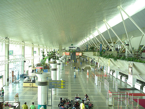
In addition to the area for international shipment are 33 square meters of space. There are also shops, including two free duty shops and a panoramic terrace, which operates within an air conditioned space. This allows the viewing of embarking and disembarking passengers without the inconvenience and danger of noise and exhaust pollution from aircraft. They are 30 check-in counters, four conveyor belts for baggage and flight information display monitors.
Administered by Infraero, the airport has a control tower, controlled approach and two runways.
Safety is a constant concern in Belém International Airport. Surveillance has been intensified and all the staff are attentive to any occurrence that might be considered suspicious. In addition, surveillance in the terminal is enhanced by multiple TV cameras.
In 2008 the airport handled 2,153,508 passengers and 39,920 aircraft movements, placing it among the busiest airports in Brazil. History
In 1934, General Eurico Gaspar Dutra, director of the Military Aviation, appointed Lieutenant Armando Sierra de Menezes to choose the Val de Cães as the land where an airport was to be built. In charge was the Directorate of Civil Aeronautics, an agency of the Ministry of Traffic and Public Works. Val de Cães was a track of land in the east west axis, sized at 1200 x 150 m. It contained a courtyard, a hangar and a parking structure of concrete for the military aircraft that over time became known as the "Hangar Yellow".
With the outbreak of World War II, the air bases and airports of the Brazilian coast became immensely important in transporting aircraft, personnel and equipment across the South Atlantic Ocean to Sierra Leone in West Africa. These facilities provided the necessary logistical support for the thousands of planes that, coming out of factories in Canada and the United States, would be moved to the theaters of operations in North Africa and Europe. After protracted negotiations between Brazil and the United States, airstrips were built at Belém for Air Transport Command with two runways measuring 1500 x 45 meters on the basis of concrete and asphalt and coating modern airport facilities to meet efficiently the civil aviation and military, the primary object deal. Val-de-Cans and other air bases used by the Americans during World War II were returned to the Ministry of Aeronautics in 1945.
Panair do Brasil, Pan American, Crux and Navegação Aérea Brasileira - NAB started activities in Val de Cães, builing their stations and providing services to passengers. In 1958, the Ministry of Aeronautics built the first passenger station for general use by the airlines. On January 24, 1959 Belém International Airport was inaugurated, to be administered by the DAC. The Brazilian Company of Airport Infrastructure was created by Law No. 5862 on 12/12/72, with the allocation to deploy, manage, operate and exploit industrial and commercial airports. In January 1974, the Ministry of Aeronautics transferred to the jurisdiction of the International Airport in Belém (Val de Cães) to Infraero, taking as the first Administrator Francisco de Assis Lopes.
The airport
Numbers
Airport site
Area: 5615783.22 meters
Apron
Area: 82,384 sq meters
Passenger terminal
Area (meters): 33,225
Parking
Capacity: 700 places
Parking of aircraft
Number of positions: 11
Address
Av. Júlio César s/n° Val de Cans Belém - PA CEP:66115-970 PABX:(91) 3210-6000 FAX:(91) 3257-1577 Distance from Downtown: 12 km
Airlines
| Airlines |
Destinations |
| Air Caraïbes |
Cayenne |
| Azul Brazilian Airlines |
Belo Horizonte-Confins [begins 3 November] |
| Gol Airlines |
Brasília, Fortaleza, Macapá, Manaus, Marabá, Recife, Rio de Janeiro-Galeão, Salvador da Bahia, Santarém, São Luís, São Paulo-Guarulhos |
| Meta |
Altamira, Itaituba, Monte Dourado, Oriximiná, Paramaribo-Johan Pengel, Santarém |
| Puma Air |
Fortaleza [begins 1 November], Macapá, São Paulo-Guarulhos |
| SETE Linhas Aéreas |
Carajás, Conceição do Araguaia, Gurupi, Marabá, Ourilândia, Redenção, Santana do Araguaia, São Félix do Xingu |
| Surinam Airways |
Paramaribo-Johan Pengel |
| TAM Airlines |
Brasília, Curitiba-Afonso Pena, Fortaleza, Foz do Iguaçu, Macapá, Manaus, Marabá, Recife, Rio de Janeiro-Galeão, Santarém, São Luís [begins 18 September], São Paulo-Congonhas, São Paulo-Guarulhos |
| TRIP Linhas Aéreas |
Altamira, Itaituba, Manaus, Parintins, Santarém |
Accidents and incidents
Accidents
- 14 July 1948: Aerovias Brasil, a Douglas C-47A-70-DL registration PP-AVO doing a cargo flight, crashed and caught fire after taking-off from Val de Cães International Airport. All 5 passengers and crew died.
- 1 December 1955: Cruzeiro do Sul, a Douglas C-47B-28-DK registration PP-CCC after take off from Val de Cães International Airport lost power on engine no.1. Consequent technical problems led the aircraft to lose altitude and the left wing struck a tree and broke off. The aircraft stalled, hit the ground and caught fire. All 6 passengers and crew died.
- 6 January 1958: Cruzeiro do Sul, a cargo Fairchild C-82A-FA Packet registration PP-CEF crashed near Val de Cães International Airport when no.1 engine caught fire after take-off. The crew of 3 died.
- 11 August 1958: Lóide Aéreo Nacional, a Douglas DC-4 registration PP-LEQ, crashed of unknown causes over Carapí Island, State of Pará while on a night time visual approach to Val de Cães International Airport. Of the 11 passengers and crew aboard, 1 passenger survived.
- 6 May 1959: Paraense, a Curtiss C-46/Super C-46 Commando registration PP-BTA crashed shortly after take-off from Val de Cães International Airport. Three crew members died.
- 22 September 1960: Paraense, a Curtiss C-46/Super C-46 Commando registration PP-BTF crashed shortly after take-off from Val de Cães International Airport. Seven occupants died.
- 14 December 1962: Panair do Brasil, a Lockheed L-049 Constellation registration PP-PDE en route from Val de Cães International Airport to Manaus - Ponta Pelada crashed in the jungle, during a night approach, due to unknown causes, approximately 45 km from Manaus at the location of Paraná da Eva. All 50 passengers and crew died.
- 14 March 1970: Paraense, a Fairchild Hiller FH-227B registration PP-BUF flying from Recife to Val de Cães International Airport, while on final approach to land, crashed into Guajará Bay. Of the 40 passengers and crew, 2 survived.
- 1 June 1973: Cruzeiro do Sul, a Sud Aviation SE-210 Caravelle VIN registration PP-PDX flying from Val de Cães International Airport to São Luiz crashed on approach to São Luiz. Engine no.1 lost power and the aircraft attained an extreme nose-up attitude. It stalled and crashed 760m to the right of the runway. All 23 passengers and crew died.
- 3 September 1989: Varig flight 254, a Boeing 737-241 registration PP-VMK flying from São Paulo-Guarulhos to Val de Cães International Airport with intermediate stops, crashed near São José do Xingu, on the last leg of the flight between Marabá and Belém due to pilot navigational error, which led to fuel exhaustion and a forced landing in the jungle. Twelve of the 48 passengers were killed in the crash. The survivors were discovered two days later.
- 6 June 1990: TABA, a Fairchild Hiller FH-227 registration PT-ICA flying from Val de Cães International Airport to Cuiabá via Altamira, Santarém, Itaituba and Alta Floresta, while on approach to land at Altamira, descended below the approach path, collided with trees and crashed 850m short of the runway. Of the 43 passengers and crew, 22 died.
- 25 January 1993: TABA, a Fairchild Hiller FH-227 registration PT-LCS operating a cargo flight from Val de Cães International Airport to Altamira crashed into the jungle near Altamira during night-time approach procedures. The crew of 3 died.
- 28 November 1995: TABA, a Fairchild Hiller FH-227 registration PP-BUJ operating a cargo flight from Val de Cães International Airport to Santarém crashed on its second attempt to approach Santarém. The crew of 2 and 1 of the 2 occupants died.
Incidents
- 8 October 1969: Cruzeiro do Sul, a Sud Aviation SE-210 Caravelle VI R en route from Val de Cães International Airport to Manaus-Ponta Pelada was hijacked by 4 persons who demanded to be flown to Cuba. The hijack lasted less than a day and there were no victims.
- 12 November 1969: Cruzeiro do Sul, a NAMC YS-11/11A en route from Manaus-Ponta Pelada to Val de Cães International Airport was hijacked by a person who demanded to be flown to Cuba. There were no victims.
- 3 February 1984: Cruzeiro do Sul, an Airbus A300B4-203 flight 302 en route from São Luiz to Val de Cães International Airport with 176 passengers and crew aboard was hijacked by 3 persons who demanded to be taken to Cuba. The flight reached Camagüey in less than a day. There were no victims.
The above content comes from Wikipedia and is published under free licenses – click here to read more.
| General Info
|
| Country |
Brazil
|
| ICAO ID |
SBBE
|
| Time |
UTC-3(-2DT)
|
| Latitude |
-1.379250
01° 22' 45.30" S
|
| Longitude |
-48.476292
048° 28' 34.65" W
|
| Elevation |
54 feet
16 meters
|
| Type |
Joint (Civil and Military)
|
| Magnetic Variation |
019° W (01/06)
|
| Beacon |
Yes
|
| Operating Agency |
MILITARY - CIVIL JOINT USE AIRPORT
|
| Near City |
Belem
|
| Operating Hours |
24 HOUR OPERATIONS
|
| International Clearance Status |
Airport of Entry
|
| Communications
|
| BELEM TWR |
118.7
|
| BELEM OPS |
122.5
|
GND
Opr 0930-0130Z++ Mon-Fri.
|
121.9
|
| BELEM ATIS |
127.6
|
| BELEM APP |
119.05
119.5
|
| Runways
|
| ID |
Dimensions |
Surface |
PCN |
ILS
|
| 02/20 |
6004 x 148 feet
1830 x 45 meters |
ASPHALT |
050FAXT |
NO
|
| 06/24 |
9180 x 148 feet
2798 x 45 meters |
ASPHALT |
065FAXT |
YES
|
| Navaids
|
| Type |
ID |
Name |
Channel |
Freq |
Distance From Field |
Bearing From Navaid
|
| VOR-DME |
BEL |
BELEM |
120X |
117.3 |
At Field |
-
|
| NDB |
IE |
VALDE |
- |
395 |
1.3 NM |
045.6
|
| Supplies/Equipment
|
| Fuel |
Jet A1, without icing nhibitor.
100/130 octane gasoline, leaded, MIL-L-5572F (GREEN)
|
| Remarks
|
| CAUTION |
Do not confuse light house at S01 27.92 W048 30.32 with arpt ABN. Bird haz. 67' obst 617' fr thld Rwy 02, 204 . Flt trng in vcnty. Twr 338' hgt 4.4 NM fr thld Rwy 02 and 2034' rgt of rwy cntrline. Twr 327' hgt 3.6 NM fr thld Rwy 02 and164' left of rwy cntrline. Pole 82' hgt 2493' 19 fr thld Rwy 02.
|
| FUEL |
A1 (Petrobras 55-21-3876-4170) (NC-100)
|
| LGT |
PAPI Rwy 02 MEHT 44'; PAPI Rwy 06 MEHT 66'.
|
| RSTD |
Acft proh fr eng runup on prk area in front of twr, AIS rpt and MET ofc. AMC chan msn will nml prk on civ ramp, while special msn will nml prk on mil ramp.
|
The content above was published at Airports-Worldwide.com in 2010.
We don't guarantee the information is fresh and accurate. The data may be wrong or outdated.
For more up-to-date information please refer to other sources.
|
|