 |
 |
|
||||
|
Images and information placed above are from www.airportsaustralia.com We thank them for the data!
2559 x 98 feet
|
|||||||||||||||||||||||||||||||||||||||||||||||||||||||||||||||||||||||||||||||||||||||||||||||||||||||||||||||||||||||||||||||||||||||||||||||||||||||||||||||||||||||||||||||||||||||||||||||||||||||||||||||||||||||||||||||||||||||||||||||||||||||||||||||||||||||||||||||||||||||||||||||||||||||||||||||||||||||||||
| Runway 04 | |
|---|---|
| Surface | GRASS OR EARTH NOT GRADED OR ROLLED. |
| True Heading | 053.0 |
| Latitude | -33.377450 33° 22' 38.82" S |
| Longitude | 149.122567 149° 07' 21.24" E |
| Elevation | 3112.0 feet 949 meters |
| Slope | -1.0° |
| Landing Distance | 2559 feet 780 meters |
| Takeoff Distance | 2559 feet 780 meters |
| Runway 22 | |
|---|---|
| Surface | GRASS OR EARTH NOT GRADED OR ROLLED. |
| True Heading | 233.0 |
| Latitude | -33.373161 33° 22' 23.38" S |
| Longitude | 149.129258 149° 07' 45.33" E |
| Elevation | 3087.0 feet 941 meters |
| Slope | 1.0° |
| Landing Distance | 2559 feet 780 meters |
| Takeoff Distance | 2559 feet 780 meters |
Runway 11/29
| Runway 11 | |
|---|---|
| Surface | ASPHALT |
| True Heading | 126.0 |
| Latitude | -33.377508 33° 22' 39.03" S |
| Longitude | 149.123767 149° 07' 25.56" E |
| Elevation | 3107.0 feet 947 meters |
| Slope | 0.1° |
| Landing Distance | 5499 feet 1676 meters |
| Takeoff Distance | 5499 feet 1676 meters |
| Lighting System | PCL
MIRL REIL PAPI |
| Runway 29 | |
|---|---|
| Surface | ASPHALT |
| True Heading | 306.0 |
| Latitude | -33.386286 33° 23' 10.63" S |
| Longitude | 149.138431 149° 08' 18.35" E |
| Elevation | 3112.0 feet 949 meters |
| Slope | -0.1° |
| Landing Distance | 5499 feet 1676 meters |
| Takeoff Distance | 5499 feet 1676 meters |
| Lighting System | PCL
MIRL REIL PAPI |
| ORANGE | |||||
|---|---|---|---|---|---|
| Type | ID | Channel | Freq | Country | State |
| NDB | ORG | - | 211 | United States | TEXAS |
| Latitude | Longitude | Airport |
| 30.070283 30° 04' 13.02" N |
-93.794944 093° 47' 41.80" W |
ORG |
| ORANGE | |||||
|---|---|---|---|---|---|
| Type | ID | Channel | Freq | Country | State |
| NDB | ORG | - | 328 | France | - |
| Latitude | Longitude | Airport |
| 44.148361 44° 08' 54.10" N |
4.857194 004° 51' 25.90" E |
LFMO |
| ORANGE | |||||
|---|---|---|---|---|---|
| Type | ID | Channel | Freq | Country | State |
| NDB | ORG | - | 424 | Australia | - |
| Latitude | Longitude | Airport |
| -33.383056 33° 22' 59.00" S |
149.124444 149° 07' 28.00" E |
YORG |
| ORANGE | |||||
|---|---|---|---|---|---|
| Type | ID | Channel | Freq | Country | State |
| TACAN | ORG | 031X | - | France | - |
| Latitude | Longitude | Airport |
| 44.139306 44° 08' 21.50" N |
4.866056 004° 51' 57.80" E |
LFMO |
| ORANGE | |||||
|---|---|---|---|---|---|
| Type | ID | Channel | Freq | Country | State |
| NDB | ORE | - | 205 | United States | MASSACHUSETTS |
| Latitude | Longitude | Airport |
| 42.568617 42° 34' 07.02" N |
-72.286111 072° 17' 10.00" W |
The content above was published at Airports-Worldwide.com in 2004-2006.
We don't guarantee the information is fresh and accurate. The data may be wrong or outdated.
For more up-to-date information please refer to other sources.

 |
|
Copyright 2004-2024 © by Airports-Worldwide.com, Vyshenskoho st. 36, Lviv 79010, Ukraine Legal Disclaimer |
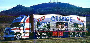 Operator: Orange City Council