|
 |
|
||||
|
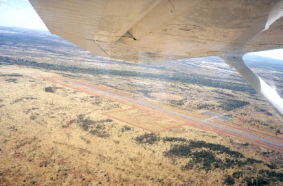
Images and information placed above are from http://www.flightclub.com.au/wa-airstrips/newman/ www.airportsaustralia.com We thank them for the data!
6798 x 98 feet
|
|||||||||||||||||||||||||||||||||||||||||||||||||||||||||||||||||||||||||||||||||||||||||||||||||||||||||||||||||||||||||||||||||||||||||||||||||||||||||||||||||||||||||||||||||||||||||||||||||||||||||||||||||||||||||||||||||||||||||||||||||
| Runway 05 | |
|---|---|
| Surface | ASPHALT |
| True Heading | 056.0 |
| Latitude | -23.423761 23° 25' 25.54" S |
| Longitude | 119.794647 119° 47' 40.73" E |
| Elevation | 1724.0 feet 525 meters |
| Slope | -0.2° |
| Landing Distance | 6798 feet 2072 meters |
| Takeoff Distance | 6798 feet 2072 meters |
| Lighting System | PCL
LIRL VA |
| Runway 23 | |
|---|---|
| Surface | ASPHALT |
| True Heading | 236.0 |
| Latitude | -23.413247 23° 24' 47.69" S |
| Longitude | 119.811425 119° 48' 41.13" E |
| Elevation | 1712.0 feet 522 meters |
| Slope | 0.2° |
| Landing Distance | 6798 feet 2072 meters |
| Takeoff Distance | 6798 feet 2072 meters |
| Lighting System | PCL
LIRL VA |
Navaids
| NEWMAN | |||||
|---|---|---|---|---|---|
| Type | ID | Channel | Freq | Country | State |
| NDB | NWN | - | 233 | Australia | - |
| Latitude | Longitude | Airport |
| -23.418056 23° 25' 05.00" S |
119.797222 119° 47' 50.00" E |
YNWN |
| NEWMAN | |||||
|---|---|---|---|---|---|
| Type | ID | Channel | Freq | Country | State |
| VOR-DME | NWN | 119X | 117.2 | Australia | - |
| Latitude | Longitude | Airport |
| -23.420833 23° 25' 15.00" S |
119.803056 119° 48' 11.00" E |
YNWN |
| NEWMAN | |||||
|---|---|---|---|---|---|
| Type | ID | Channel | Freq | Country | State |
| VORTAC | EWM | 071X | 112.4 | United States | TEXAS |
| Latitude | Longitude | Airport |
| 31.951744 31° 57' 06.28" N |
-106.272400 106° 16' 20.64" W |
KBIF |
The content above was published at Airports-Worldwide.com in 2004-2006.
We don't guarantee the information is fresh and accurate. The data may be wrong or outdated.
For more up-to-date information please refer to other sources.

 |
|
Copyright 2004-2024 © by Airports-Worldwide.com, Vyshenskoho st. 36, Lviv 79010, Ukraine Legal Disclaimer |
 Operator: East Pilbra Ahire Council