 |
|
|
|
|
|
 Operator: Longreach Shire Council
Address:
PO Box 472
Longreach QLD 4730
Australia
Phone: +61 7 46584111
Fax: +61 7 46584116
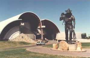
Longreach is located 1205km north west of Brisbane on the Landsborough (Matilda) Highway and 689km west of Rockhampton on the Tropic of Capricorn. The Stockman's Hall of Fame (pictured) and Outback Heritage Centre is leading the way in this regard with a number of other increasingly popular attractions such as the Qantas Founders Outback Museum.
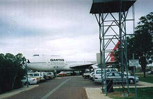
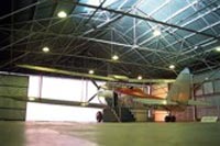
 Longreach was one of the founding centres for the Australian domestic and international airline, Qantas. One of the airlines original hangars remains in use at the Longreach Airport. The town is now the home of the Qantas Founders Outback Museum, which includes amongst its displays a decommissioned Qantas Boeing 747 aircraft, VH-EBQ, "The City of Bunbury".
Longreach Airport is situated in rural Queensland, Australia.
 Longreach has played a major part in Australian aviation from 1919 onwards. In August of that year, a small party left the town to travel overland to survey a route suitable for competitors in the first air race to leave England enroute to Australia. The travellers included Hudson Fysh and Paul McGinness, two pilots who had both been trained in the Australian Flying Corps during the First World War. In December 1919, a Vickers Vimy landed, piloted by Ross and Keith Smith, who were enroute to Melbourne after completing the first flight from England to Australia. They were the first to use the air route pioneered by Fysh and McGinness.
The first overland flight across the Australian continent from Melbourne to Darwin passed through the airport in 1919. This flight was undertaken by Captain H.N. Wrigley and Sergeant A.W. Murphy,flying a BE2.
In 1920, the first single engine aircraft to complete the flight from England to Australia arrived. The aircraft was a de Havilland DH9, piloted by Ray Parer and John McIntosh.
In late 1920, the Queensland and Northern Territory Aerial Service was founded. Although founded in Winton, the first operational base for the airline, later to be known as QANTAS, was Longreach. Principal among the pioneers of the airline were Hudson Fysh and Paul McGinness, who had seen the opportunities aviation had presented to remote Australia during their survey the previous year. One of the original Qantas hangars survives at the airport to this day.
Charles Kingsford Smith arrived in 1927, during a flight around the continent. His aircraft on this occasion was a Bristol Tourer
In 1941, the Department of Civil Aviation established the Longreach Aeradio station at the airport. This unit enabled air ground communication with the increasing number of radio equipped aircraft operating throughout the country.
During the Second World War, Longreach airport became, for a short time in 1942, a base for American B-17 bomber aircraft. The airport was upgraded to cater for the additional weight of these aircraft. In May, these aircraft were flown from the town to engage the enemy in the Battle of the Coral Sea. Used shell casings from the guns of these aircraft can still be found adjacent to the runways. By this stage, the airport had three operational runways.
At one time in the 1960s, Longreach airport was one of the busiest inland airports in Australia. However, with drought and the general downturn of the rural economy throughout the country, air traffic declined.
In 1990, the Department of Aviation closed the Longreach Flight Service Unit, the descendant of the Aeradio station opened in 1941. The airport was transferred to the ownership of the Longreach Shire Council shortly thereafter. Two runways remain at the airport: a fully sealed all weather runway, and a shorter partly sealed runway.
In 2003, Qantas returned to the town, with a Boeing 747 aircraft flown into the town for static display at the Qantas Founders Outback Museum, which is also sited at the airport.
URL: Longreach Airport
Images and information placed above are from
Longreach
Airport
We thank them for the data!
| General Info
|
| Country |
Australia
|
| ICAO ID |
YLRE
|
| Time |
UTC+10
|
| Latitude |
-23.434167
23° 26' 03.00" S
|
| Longitude |
144.280278
144° 16' 49.00" E
|
| Elevation |
627 feet
191 meters
|
| Magnetic Variation |
008° E (01/04)
|
| Beacon |
Yes
|
| Operating Agency |
CIVIL GOVERNMENT, (LANDING FEES AND DIPLOMATIC CLEARANCE MAY BE REQUIRED)
|
| Communications
|
| BRISBANE CNTR |
122.1
|
| MTAF |
126.7
|
| Communications Remarks |
|
| CTAF |
Nstd to 5700', excluding R608.
|
| FSS |
(on gnd)
|
| Runways
|
| ID |
Dimensions |
Surface |
PCN |
ILS
|
| 04/22 |
6352 x 98 feet
1936 x 30 meters |
ASPHALT |
024FCXT |
NO
|
| 09/27 |
2953 x 59 feet
900 x 18 meters |
GRAVEL. |
- |
NO
|
| Navaids
|
| Type |
ID |
Name |
Channel |
Freq |
Distance From Field |
Bearing From Navaid
|
| VOR |
LRE |
LONGREACH |
- |
117.9 |
At Field |
-
|
| NDB |
LRE |
LONGREACH |
- |
353 |
At Field |
-
|
| Supplies/Equipment
|
| Fuel |
Jet A1, without icing nhibitor.
100/130 MIL Spec, low lead, aviation gasoline (BLUE)
|
| Oil |
O-117, 1100, Reciprocating Engine Oil (MIL L 6082)
|
| Remarks
|
| CAUTION |
Bird and animal haz.
|
| FUEL |
Avbl 2100-0700Z Mon-Fri OT PN, fone C07-4658-1520. (NC-100LL, A1)
|
| LGT |
PPR fone 07 4658 4111. ACTIVATE-Rwy 04-22-125.3. SR-SS PAL only activates PAPI.Portable lgt emerg only.
|
| MISC |
Rwy 09-27 600' asphalt W end. Ldg fees.
|
| OIL |
O-117.
|
Runway 04/22
6352 x 98 feet
1936 x 30 meters
| Runway 04
|
| Surface |
ASPHALT
|
| True Heading |
047.0
|
| Latitude |
-23.437989
23° 26' 16.76" S
|
| Longitude |
144.270675
144° 16' 14.43" E
|
| Elevation |
626.0 feet
191 meters
|
| Slope |
0.0°
|
| Landing Distance |
6352 feet
1936 meters
|
| Takeoff Distance |
6352 feet
1936 meters
|
| Lighting System |
PCL
LIRL
PAPI
PORTABLE |
| Runway 22
|
| Surface |
ASPHALT
|
| True Heading |
227.0
|
| Latitude |
-23.425978
23° 25' 33.52" S
|
| Longitude |
144.284417
144° 17' 03.90" E
|
| Elevation |
623.0 feet
190 meters
|
| Slope |
0.0°
|
| Landing Distance |
6352 feet
1936 meters
|
| Takeoff Distance |
6352 feet
1936 meters
|
| Lighting System |
PCL
LIRL
PAPI
PORTABLE |
Runway 09/27
2953 x 59 feet
900 x 18 meters
| Runway 09
|
| Surface |
GRAVEL.
|
| True Heading |
093.0
|
| Latitude |
-23.437597
23° 26' 15.35" S
|
| Longitude |
144.270439
144° 16' 13.58" E
|
| Elevation |
624.0 feet
190 meters
|
| Landing Distance |
2953 feet
900 meters
|
| Takeoff Distance |
2953 feet
900 meters
|
| Runway 27
|
| Surface |
GRAVEL.
|
| True Heading |
273.0
|
| Latitude |
-23.438022
23° 26' 16.88" S
|
| Longitude |
144.279233
144° 16' 45.24" E
|
| Elevation |
625.0 feet
191 meters
|
| Landing Distance |
2953 feet
900 meters
|
| Takeoff Distance |
2953 feet
900 meters
|
Navaids
| LONGREACH
|
| Type |
ID |
Channel |
Freq |
Country |
State
|
| NDB |
LRE |
- |
353 |
Australia |
-
|
| Latitude |
Longitude |
Airport
|
-23.428333
23° 25' 42.00" S |
144.289167
144° 17' 21.00" E |
YLRE
|
| LONGREACH
|
| Type |
ID |
Channel |
Freq |
Country |
State
|
| VOR |
LRE |
- |
117.9 |
Australia |
-
|
| Latitude |
Longitude |
Airport
|
-23.424444
23° 25' 28.00" S |
144.282222
144° 16' 56.00" E |
YLRE
|
The content above was published at Airports-Worldwide.com in 2004-2006.
We don't guarantee the information is fresh and accurate. The data may be wrong or outdated.
For more up-to-date information please refer to other sources.
|
 |


