 |
 |
|
||||
|
Images and information placed above are from www.airportsaustralia.com http://www.aizuddindanian.com/voi/archives/2003/12 We thank them for the data!
Runway 05/235604 x 148 feet
|
|||||||||||||||||||||||||||||||||||||||||||||||||||||||||||||||||||||||||||||||||||||||||||||||||||||||||||||||||||||||||||||||||||||||||||||||||||||||||||||||||||||||||||||||||||||||||||||||||||||||||||||||||||||||||||||||||||||||||||||||||||||||||||||
| Runway 05 | |
|---|---|
| Surface | ASPHALT |
| True Heading | 053.0 |
| Latitude | -32.222822 32° 13' 22.16" S |
| Longitude | 148.568836 148° 34' 07.81" E |
| Elevation | 935.0 feet 285 meters |
| Slope | -0.6° |
| Landing Distance | 5604 feet 1708 meters |
| Takeoff Distance | 5604 feet 1708 meters |
| Lighting System | PCL
LIRL VA |
| Runway 23 | |
|---|---|
| Surface | ASPHALT |
| True Heading | 233.0 |
| Latitude | -32.213708 32° 12' 49.35" S |
| Longitude | 148.583453 148° 35' 00.43" E |
| Elevation | 903.0 feet 275 meters |
| Slope | 0.6° |
| Landing Distance | 5604 feet 1708 meters |
| Takeoff Distance | 5604 feet 1708 meters |
| Lighting System | PCL
LIRL VA |
| Runway 11 | |
|---|---|
| Surface | ASPHALT |
| True Heading | 119.0 |
| Latitude | -32.214372 32° 12' 51.74" S |
| Longitude | 148.573447 148° 34' 24.41" E |
| Elevation | 910.0 feet 277 meters |
| Slope | 0.5° |
| Landing Distance | 3501 feet 1067 meters |
| Takeoff Distance | 3501 feet 1067 meters |
| Runway 29 | |
|---|---|
| Surface | ASPHALT |
| True Heading | 299.0 |
| Latitude | -32.219044 32° 13' 08.56" S |
| Longitude | 148.583342 148° 35' 00.03" E |
| Elevation | 927.0 feet 283 meters |
| Slope | -0.5° |
| Landing Distance | 3501 feet 1067 meters |
| Takeoff Distance | 3501 feet 1067 meters |
| DUBBO | |||||
|---|---|---|---|---|---|
| Type | ID | Channel | Freq | Country | State |
| NDB | DU | - | 251 | Australia | - |
| Latitude | Longitude | Airport |
| -32.217531 32° 13' 03.11" S |
148.559094 148° 33' 32.74" E |
YSDU |
| DUBBO | |||||
|---|---|---|---|---|---|
| Type | ID | Channel | Freq | Country | State |
| VOR-DME | DU | 091X | 114.4 | Australia | - |
| Latitude | Longitude | Airport |
| -32.219528 32° 13' 10.30" S |
148.577708 148° 34' 39.75" E |
YSDU |
The content above was published at Airports-Worldwide.com in 2004-2006.
We don't guarantee the information is fresh and accurate. The data may be wrong or outdated.
For more up-to-date information please refer to other sources.

 |
|
Copyright 2004-2024 © by Airports-Worldwide.com, Vyshenskoho st. 36, Lviv 79010, Ukraine Legal Disclaimer |
 Operator: Dubbo City Council
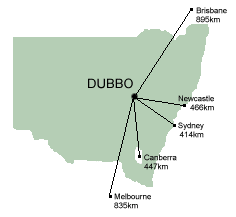
  Dubbo is also located within a 2 hour radius of some of Inland Western
NSW's major attractions, which is why many people choose to stay in Dubbo
for several days while touring NSW or Eastern Australia.There are flights
to and from Dubbo several times a day, and daily bus and train services.
A typical trip from Sydney takes about 50 minutes by air.
Dubbo is also located within a 2 hour radius of some of Inland Western
NSW's major attractions, which is why many people choose to stay in Dubbo
for several days while touring NSW or Eastern Australia.There are flights
to and from Dubbo several times a day, and daily bus and train services.
A typical trip from Sydney takes about 50 minutes by air.