 |
|
|
|
|
|
 The full jet airport is 8 kilometres from the City Centre and 5km from
the TT-Line's 'Spirit of Tasmania' terminal in East Devonport.
The full jet airport is 8 kilometres from the City Centre and 5km from
the TT-Line's 'Spirit of Tasmania' terminal in East Devonport.
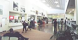
Owned and operated by the Port of Devonport Corporation, the modern, friendly
Airport has full terminal facilities and services, including hire cars
and shuttle buses to the City.
Devonport Airport is the closest port of entry to the Tasmanian Wilderness
and Cradle Mountain National Park, which is only 80 minutes from the Airport.
An easy drive to Hobart (270km), Launceston (80km) and the West Coast,
Devonport is the perfect entry point for a Tasmanian holiday.
QantasLink conducts regular scheduled commercial services from Devonport.
They provide return flights to Melbourne, with connections to interstate
and international networks.
Intrastate operator, Tasair provides passenger and freight services to
King Island and Hobart. Tasair also offers charter services, pilot training,
aircraft hire, aerial photography, wilderness scenic flights and freight
services.
Sureflight Aviation offer a range of services fixed wing and helicopter
services plus aircraft repairs and maintenance.
Devonport Airport
Address: PO Box 478 Devonport Tasmania Australia 7310
Port Admin: 48 Formby Road Devonport
Phone: +61 3 6421 4911
Fax: +61 3 6421 4988
E-mail: enquiries at portdev com au
URL: Devonport
Airport
Images and information placed above are from
Devonport
Airport
We thank them for the data!
| General Info
|
| Country |
Australia
|
| ICAO ID |
YDPO
|
| Time |
UTC+10(+11DT)
|
| Latitude |
-41.169722
41° 10' 11.00" S
|
| Longitude |
146.430278
146° 25' 49.00" E
|
| Elevation |
33 feet
10 meters
|
| Magnetic Variation |
013° E (01/04)
|
| Beacon |
Yes
|
| Operating Agency |
CIVIL GOVERNMENT, (LANDING FEES AND DIPLOMATIC CLEARANCE MAY BE REQUIRED)
|
| Communications
|
| MTAF |
126.9
|
| MELBOURNE CNTR |
120.7
|
| Communications Remarks |
|
| MISC |
Nstd DPO-WYY is a single CTLZ to 7500' (excld the 4500' CTA step)
|
| FSS |
(on gnd)
|
| Runways
|
| ID |
Dimensions |
Surface |
PCN |
ILS
|
| 06/24 |
6030 x 148 feet
1838 x 45 meters |
ASPHALT |
029FCYT |
NO
|
| 14/32 |
2887 x 98 feet
880 x 30 meters |
GRASS OR EARTH NOT GRADED OR ROLLED. |
- |
NO
|
| Navaids
|
| Type |
ID |
Name |
Channel |
Freq |
Distance From Field |
Bearing From Navaid
|
| VOR-DME |
DPO |
DEVONPORT |
110X |
116.3 |
At Field |
-
|
| NDB |
DPO |
DEVONPORT |
- |
281 |
At Field |
-
|
| Supplies/Equipment
|
| Fuel |
Jet A1, without icing nhibitor.
100/130 MIL Spec, low lead, aviation gasoline (BLUE)
|
| Remarks
|
| CAUTION |
Bird haz.
|
| FUEL |
(NC-A1) Avbl 2000-0830Z++ OT PN, fone C04 17397828. (NC-100LL) Avbl 30 min PN fone C03 64279777.
|
| LGT |
ACTIVATE-Rwy 06-24-122.3.
|
| MISC |
Rwy 06-24 grooved. Ldg fees.
|
| TFC PAT |
Rgt hand circuits Rwy 24
|
Runway 06/24
6030 x 148 feet
1838 x 45 meters
| Runway 06
|
| Surface |
ASPHALT
|
| True Heading |
076.0
|
| Latitude |
-41.169733
41° 10' 11.04" S
|
| Longitude |
146.419144
146° 25' 08.92" E
|
| Elevation |
18.0 feet
5 meters
|
| Slope |
0.1°
|
| Landing Distance |
6030 feet
1838 meters
|
| Takeoff Distance |
6030 feet
1838 meters
|
| Lighting System |
PCL
LIRL
VA |
| Runway 24
|
| Surface |
ASPHALT
|
| True Heading |
256.0
|
| Latitude |
-41.165761
41° 09' 56.74" S
|
| Longitude |
146.440403
146° 26' 25.45" E
|
| Elevation |
22.0 feet
7 meters
|
| Slope |
-0.1°
|
| Landing Distance |
6030 feet
1838 meters
|
| Takeoff Distance |
6030 feet
1838 meters
|
| Lighting System |
PCL
LIRL
VA |
Runway 14/32
2887 x 98 feet
880 x 30 meters
| Runway 14
|
| Surface |
GRASS OR EARTH NOT GRADED OR ROLLED.
|
| True Heading |
155.0
|
| Latitude |
-41.165692
41° 09' 56.49" S
|
| Longitude |
146.428572
146° 25' 42.86" E
|
| Landing Distance |
2887 feet
880 meters
|
| Takeoff Distance |
2887 feet
880 meters
|
| Runway 32
|
| Surface |
GRASS OR EARTH NOT GRADED OR ROLLED.
|
| True Heading |
335.0
|
| Latitude |
-41.172936
41° 10' 22.57" S
|
| Longitude |
146.432819
146° 25' 58.15" E
|
| Landing Distance |
2887 feet
880 meters
|
| Takeoff Distance |
2887 feet
880 meters
|
Navaids
| DEVONPORT
|
| Type |
ID |
Channel |
Freq |
Country |
State
|
| NDB |
DPO |
- |
281 |
Australia |
-
|
| Latitude |
Longitude |
Airport
|
-41.173925
41° 10' 26.13" S |
146.428553
146° 25' 42.79" E |
YDPO
|
| DEVONPORT
|
| Type |
ID |
Channel |
Freq |
Country |
State
|
| VOR-DME |
DPO |
110X |
116.3 |
Australia |
-
|
| Latitude |
Longitude |
Airport
|
-41.170000
41° 10' 12.00" S |
146.434167
146° 26' 03.00" E |
YDPO
|
The content above was published at Airports-Worldwide.com in 2004-2006.
We don't guarantee the information is fresh and accurate. The data may be wrong or outdated.
For more up-to-date information please refer to other sources.
|
 |


