 |
|
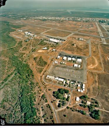
Darwin International Airport |
|
|
 We hope that Darwin International Airport provides you with an enjoyable travel experience and wish you a happy and safe journey.
Strategic Location
Darwin is well placed to serve as an Australian gateway of regional significance to/from South East Asia. It is the only large population centre in an isolated 5,600 km stretch of coast from Cairns to Perth. Strategically located on the "apex" of Australia, Darwin is the nearest capital city to the still developing areas of eastern Indonesia, eastern Malaysia and the southern Philippines.
Locality
Darwin International Airport is located 13 kilometres north east of the Darwin Central Business District, lying between the central city areas to the south west and the main district centre of Casuarina to the north.
The airport is bounded by:
 � Stuart Highway and Winnellie Industrial Area to the south
� McMillans Road and Marrara sporting fields to the north
� Bagot Road and residential and industrial areas to the west, and
� Amy Johnston Avenue and Marrara wetlands to the east.
Access to the terminal is via Henry Wrigley Drive, off McMillans Road.
History
The first aerodrome at Darwin was located on what was known locally as the Parap Police Paddock. It was selected in 1919 to provide the Australian Terminal for the England to Australia air race. The first aircraft arrived from England during December 1919, two days later the first flight across Australia from the south also landed on the site.
The Parap aerodrome was developed progressively along the alignment of what is now Ross Smith Avenue. It served as the sole land aerodrome at Darwin until July 1940 when the existing aerodrome was commissioned by the RAAF. The Parap aerodrome continued to be used until the end of 1945.
In 1945 the Department of Aviation made the existing Darwin military airfield available for civil aviation purposes under the terms of a joint-user policy which included a requirement for a civil building area to be developed as a self contained entity.
At that time all building development on the site was in the south west section of the aerodrome and it was agreed that with the low level of aviation activity then existing in Darwin, civil aviation operations could be established within the RAAF area utilising mainly existing facilities.
Initially civil passenger traffic was handled in the end of a former RAAF hangar. As the traffic grew the terminal facilities expanded to occupy the whole building and in the surrounding areas the apron, car parks and roads became severely congested.
By the late 1950's it was recognised that the civil aviation activities would need to move from the RAAF area and possibly ultimately to the northern area of the aerodrome. However, due to the cost of developing the northern area and the still relatively low levels of aviation activity it was decided that civil aviation facilities could be developed in the area east of the 18/36 runway.
The RAAF upgraded the runways during the latter part of the 1950s and early 1960s. The present high strength 11/29 main runway was completed in 1962 and paved for a length of 3,354 metres. In 1964, the full length (1524 metres) of the 18/36 secondary runway was reconstructed and resealed.
In the early 1960's development of the area east of the 18/36 runway commenced. A new fire station was co-located with a new RAAF control tower, an operations Air Traffic Control/Communication (ATC/COM) Centre, meteorological facilities, power houses, technical maintenance facilities and a general aviation hangar area were established.
The constrained area available for civil aviation use and the expansion and security needs of both civil aviation and the RAAF resulted in renewed efforts to establish civil aviation facilities separated from the RAAF.
Between 1970 and 1982 a number of studies were undertaken which included consideration of relocation of both RAAF and civil aviation for a new site.
In 1980 it was concluded that the civil operations should relocate to the northern side of the main runway. Following further RAAF studies of its requirements the Department of Aviation recommended a staged development which was adopted by the Government in November 1982. Subsequently development of the site commenced in 1984 but was halted by the Government in 1985 over concern at the cost.
In the latter half of the 1980's the Government actively implemented policies which removed the planning, development, operation, and maintenance of civil aviation facilities from departmental control and the Commonwealth Budget.
On 1 April 1989 the Federal Airports Corporation (FAC) assumed responsibility for the planning, development, operation and maintenance of the civil facilities on Darwin International Airport and the land required for civil operations was acquired from the Department of Defence (RAAF). The FAC immediately commenced planning of the development of 311 hectares of land located on the north side of the 11/29 runway. It followed closely a Provisional Master Plan prepared by the Department of Aviation in 1983.
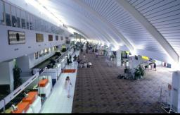
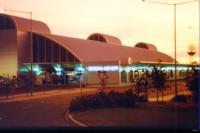
In January 1990 the FAC awarded a $55 million contract to design and construct a new domestic/international terminal, aprons, taxiways, roads and car parks. Separate helicopter and general aviation aprons and taxiways and associated services were also included as part of the project. Operations commenced from the new terminal on 15
December 1991 and effectively separated civil and military activities at Darwin International Airport.
During 1998 a new Fire Station and Control Tower were constructed within the civil areas to the north of the runway. The Fire Station was commissioned in 1999 and the control tower in 2000. Between 1995 and 1998 the FAC further developed access roads and extended the long term public, hire car and staff car parks and carried out taxiway enhancements.
On 10 June 1998, Northern Territory Airports Pty Ltd obtained a 50-year lease, plus a 49 year option from the Commonwealth Government to manage and develop the civil area of Darwin International Airport (DIA). The airport is a joint user facility shared with the Royal Australian Air Force (RAAF). The airport-leased area is to the north and consists of 311 hectares of land. The Department of Defence owns the RAAF base to the southeast.
In September 1998, an additional taxiway was constructed to provide airside access to local operators, Pel-Air and Airnorth, located to the east of the terminal.
In 1999, the Commonwealth Minister for Transport and Regional Services approved the 20 year Master Plan in accordance with Section 81 of the Airports Act 1996. This plan provides the framework for Darwin International Airport's future development.
 Street Address:
Airport Management Centre, 1 Fenton Court, MARRARA Northern Territory 0812, Australia
Postal Address:
Post Office Box 40996, CASUARINA Northern Territory 0811, Australia
Telephone: (Main Reception) 61 8 8920 1811
Facsimile:
Management Centre: 61 8 8920 1800,
Terminal Control Centre: 61 8 8920 1855
Email: information drw at ntairports com au
URL: www.darwinairport com au
Images and information placed above are from
www.darwinairport com au
We thank them for the data!
| General Info
|
| Country |
Australia
|
| ICAO ID |
YPDN
|
| Time |
UTC+9:30
|
| Latitude |
-12.414722
12° 24' 53.00" S
|
| Longitude |
130.876667
130° 52' 36.00" E
|
| Elevation |
103 feet
31 meters
|
| Type |
Joint (Civil and Military)
|
| Magnetic Variation |
003° E (01/04)
|
| Beacon |
Yes
|
| Operating Agency |
MILITARY - CIVIL JOINT USE AIRPORT
|
| International Clearance Status |
Airport of Entry
|
| Communications
|
| TWR |
133.1
257.8
|
| RAAF AIR OPS |
8974
11235
13206
3032
5687
|
| GND |
121.8
119.55
265.3
|
| DARWIN CNTR |
125.2
305.5
|
| DEP |
123.0
325.4
|
| CLNC DEL |
126.8
237.3
|
| ATIS |
112.6
308.0
316.2
344.0
|
| APP |
125.2
134.1
305.5
363.8
|
| Communications Remarks |
|
| MISC |
.8974 11235 13206 Opr 2100-0900Z. 3032 5687 8974 Opr 0900-2100Z.
|
| A/D |
(125.2, 305.5 E of Rwy 18-36)(134.1, 363.8 W of Rwy 18-36)
|
| Runways
|
| ID |
Dimensions |
Surface |
PCN |
ILS
|
| 11/29 |
11004 x 197 feet
3354 x 60 meters |
ASPHALT |
066FCXU |
YES
|
| 18/36 |
5000 x 98 feet
1524 x 30 meters |
ASPHALT |
018FCXU |
NO
|
| Navaids
|
| Type |
ID |
Name |
Channel |
Freq |
Distance From Field |
Bearing From Navaid
|
| TACAN |
DAR |
DARWIN |
084X |
- |
At Field |
-
|
| VOR-DME |
DN |
DARWIN |
073X |
112.6 |
1.8 NM |
282.5
|
| NDB |
HWS |
HOWARD SPRINGS |
- |
257 |
10.3 NM |
284.7
|
| Supplies/Equipment
|
| Fuel |
Jet A1, without icing nhibitor.
100/130 MIL Spec, low lead, aviation gasoline (BLUE)
Unknown fuel type or whether there is any fuel.
|
| Oil |
O-117, 1100, Reciprocating Engine Oil (MIL L 6082)
|
| JASU |
-
|
| Remarks
|
| A-GEAR |
BAK-12/14 bi-directional hook cables ea end Rwy 11-29 cables are recessed into rwy, no cros speed rstd in down posn. In the event of pwr failure, cables will rise to a height of 10 CM til pwr is restored.
|
| CAUTION |
Possible wind shear/turbulence on short final all rwys. Bird haz. Several rifle ranges wi Darwin CTLZ, activity indicated by red flags. Model acft opr to 400', 270 2.9 NM fr AD.
|
| FUEL |
(NC-100LL) Avbl 2200-0930Z Mon-Fri, exc hol, 2200-0400Z Sat; fone C0438 450038. (NC-A1, A1+).
|
| JASU |
1(E14) C CM 1(A1) 1(E1) 1(E4) 1(E5) 1(E6) 1(E9) .
|
| LGT |
Portable lgts PN.
|
| MISC |
Rwy 11-29 wt limits: L1011-414,000 lb. Rwy 18-36 avbl as twy S of Rwy 11-29 SS-SR. Rwy 11-29 grooved.
|
| NS ABTMT |
See FLIP PLANNING AP/3.
|
| OIL |
O-117.
|
| RSTD |
RAAF refueling of MIL ACFT 24 HR PN. PPR for overnight prk, fone C08 8920 1850. All Mil and Mil Charter (incl foreign Mil) acft req handling at RAAF Darwin are to CTC the Base Command Post, fone C61 8923 5594. Rwy 11-29 acft abv 220,460 lbs(except B767) 180 turns only at rwy ends.
|
Runway 11/29
11004 x 197 feet
3354 x 60 meters
| Runway 11
|
| Surface |
ASPHALT
|
| True Heading |
109.0
|
| Latitude |
-12.409408
12° 24' 33.87" S
|
| Longitude |
130.865256
130° 51' 54.92" E
|
| Elevation |
96.0 feet
29 meters
|
| Slope |
-0.1°
|
| Landing Distance |
11004 feet
3354 meters
|
| Takeoff Distance |
11004 feet
3354 meters
|
| Lighting System |
HIRL
VA |
| Runway 29
|
| Surface |
ASPHALT
|
| True Heading |
289.0
|
| Latitude |
-12.419233
12° 25' 09.24" S
|
| Longitude |
130.894439
130° 53' 39.98" E
|
| Elevation |
81.0 feet
25 meters
|
| Slope |
0.1°
|
| Landing Distance |
11004 feet
3354 meters
|
| Takeoff Distance |
11004 feet
3354 meters
|
| Lighting System |
HIRL
J
VA |
Runway 18/36
5000 x 98 feet
1524 x 30 meters
| Runway 18
|
| Surface |
ASPHALT
|
| True Heading |
180.0
|
| Latitude |
-12.408778
12° 24' 31.60" S
|
| Longitude |
130.870653
130° 52' 14.35" E
|
| Elevation |
97.0 feet
30 meters
|
| Slope |
-0.1°
|
| Landing Distance |
5000 feet
1524 meters
|
| Takeoff Distance |
5000 feet
1524 meters
|
| Lighting System |
PORTABLE
|
| Runway 36
|
| Surface |
ASPHALT
|
| True Heading |
360.0
|
| Latitude |
-12.422625
12° 25' 21.45" S
|
| Longitude |
130.870689
130° 52' 14.48" E
|
| Elevation |
92.0 feet
28 meters
|
| Slope |
0.1°
|
| Landing Distance |
5000 feet
1524 meters
|
| Takeoff Distance |
5000 feet
1524 meters
|
| Lighting System |
PORTABLE
|
Navaids
| DARWIN
|
| Type |
ID |
Channel |
Freq |
Country |
State
|
| VORTAC |
DWN |
027X |
109 |
United States |
MINNESOTA
|
| Latitude |
Longitude |
Airport
|
45.087464
45° 05' 14.87" N |
-94.453850
094° 27' 13.86" W |
HCD
|
| DARWIN
|
| Type |
ID |
Channel |
Freq |
Country |
State
|
| NDB |
DN |
- |
344 |
Australia |
-
|
| Latitude |
Longitude |
Airport
|
-12.431389
12° 25' 53.00" S |
130.961389
130° 57' 41.00" E |
YPDN
|
| DARWIN
|
| Type |
ID |
Channel |
Freq |
Country |
State
|
| VOR-DME |
DN |
073X |
112.6 |
Australia |
-
|
| Latitude |
Longitude |
Airport
|
-12.423056
12° 25' 23.00" S |
130.906111
130° 54' 22.00" E |
YPDN
|
| DARWIN
|
| Type |
ID |
Channel |
Freq |
Country |
State
|
| TACAN |
DAR |
084X |
- |
Australia |
-
|
| Latitude |
Longitude |
Airport
|
-12.413333
12° 24' 48.00" S |
130.883333
130° 53' 00.00" E |
YPDN
|
Navaids
| HOWARD SPRINGS
|
| Type |
ID |
Channel |
Freq |
Country |
State
|
| NDB |
HWS |
- |
257 |
Australia |
-
|
| Latitude |
Longitude |
Airport
|
-12.468889
12° 28' 08.00" S |
131.043056
131° 02' 35.00" E |
YPDN
|
The content above was published at Airports-Worldwide.com in 2004-2006.
We don't guarantee the information is fresh and accurate. The data may be wrong or outdated.
For more up-to-date information please refer to other sources.
|
 |


