|
|
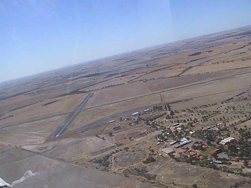 |
Photo credit: James Cooper (Glider
Pilot)
This photo shows the agricultural college in the foreground looking
out to the west
(Click on the photo to enlarge) |
Images and information placed above are from
http://www.flightclub.com.au/wa-airstrips/cunderdin/
We thank them for the data!
| General Info
|
| Country |
Australia
|
| ICAO ID |
YCUN
|
| Time |
UTC+8
|
| Latitude |
-31.622223
31° 37' 20.00" S
|
| Longitude |
117.216667
117° 13' 00.00" E
|
| Elevation |
705 feet
215 meters
|
| Magnetic Variation |
001° W (01/06)
|
| Operating Agency |
CIVIL GOVERNMENT, (LANDING
FEES AND DIPLOMATIC CLEARANCE MAY BE REQUIRED)
|
| Communications
|
| MELBOURNE CNTR |
120.3
|
| CTAF |
126.7
|
| Communications Remarks |
|
| FSS |
(3000')
|
| Runways
|
ID
|
Dimensions |
Surface |
PCN |
ILS
|
| 05/23 |
6089 x 148 feet
1856 x 45 meters |
ASPHALT |
- |
NO
|
| 14/32 |
4997 x 148 feet
1523 x 45 meters |
ASPHALT |
- |
NO
|
| Navaids
|
| Type |
ID |
Name |
Channel |
Freq |
Distance From Field |
Bearing From Navaid
|
| NDB |
CUN |
CUNDERDIN |
- |
293 |
At Field |
-
|
| Remarks
|
| CAUTION |
Glider opr SR-SS, Gliders monitor 122.7
|
| LGT |
ACTIVATE - Rwy 05-23 126.7.
|
| MISC |
Arpt unlicensed. Ctc arpt for current info. Fone C089-635-1005. Ldg fee.
|
Runway 05/23
6089 x 148 feet
1856 x 45 meters
| Runway 05
|
| Surface |
ASPHALT
|
| True Heading |
045.0
|
| Latitude |
-31.627778
31° 37' 40.00" S
|
| Longitude |
117.209439
117° 12' 33.98" E
|
| Elevation |
689.0 feet
210 meters
|
| Slope |
0.3°
|
| Landing Distance |
6089 feet
1856 meters
|
| Takeoff Distance |
6089 feet
1856 meters
|
| Lighting System |
PCL
LIRL |
| Runway 23
|
| Surface |
ASPHALT
|
| True Heading |
225.0
|
| Latitude |
-31.616667
31° 37' 00.00" S
|
| Longitude |
117.223889
117° 13' 26.00" E
|
| Elevation |
705.0 feet
215 meters
|
| Slope |
-0.3°
|
| Landing Distance |
6089 feet
1856 meters
|
| Takeoff Distance |
6089 feet
1856 meters
|
| Lighting System |
PCL
LIRL |
Runway 14/32
4997 x 148 feet
1523 x 45 meters
| Runway 14
|
| Surface |
ASPHALT
|
| True Heading |
135.0
|
| Latitude |
-31.616667
31° 37' 00.00" S
|
| Longitude |
117.211389
117° 12' 41.00" E
|
| Elevation |
700.0 feet
213 meters
|
| Slope |
-0.1°
|
| Landing Distance |
4997 feet
1523 meters
|
| Takeoff Distance |
4997 feet
1523 meters
|
| Runway 32
|
| Surface |
ASPHALT
|
| True Heading |
315.0
|
| Latitude |
-31.627222
31° 37' 38.00" S
|
| Longitude |
117.221950
117° 13' 19.02" E
|
| Elevation |
694.0 feet
212 meters
|
| Slope |
0.1°
|
| Landing Distance |
4997 feet
1523 meters
|
| Takeoff Distance |
4997 feet
1523 meters
|
Navaids
| CUNDERDIN
|
| Type |
ID |
Channel |
Freq |
Country |
State
|
| NDB |
CUN |
- |
293 |
Australia |
-
|
| Latitude |
Longitude |
Airport
|
-31.625000
31° 37' 30.00" S |
117.223889
117° 13' 26.00" E |
YCUN |
The content above was published at Airports-Worldwide.com in 2004-2006.
We don't guarantee the information is fresh and accurate. The data may be wrong or outdated.
For more up-to-date information please refer to other sources.
|


