|
 |
|
||||
|
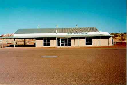
Images and information placed above are from www.airportsaustralia.com http://www.brice-eng.com.au/cloncurr.htm We thank them for the data!
Runway 06/243796 x 60 feet
|
|||||||||||||||||||||||||||||||||||||||||||||||||||||||||||||||||||||||||||||||||||||||||||||||||||||||||||||||||||||||||||||||||||||||||||||||||||||||||||||||||||||||||||||||||||||||||||||||||||||||||||||||||||||||||||||||||
| Runway 06 | |
|---|---|
| Surface | ASPHALT |
| True Heading | 068.0 |
| Latitude | -20.670308 20° 40' 13.11" S |
| Longitude | 140.498544 140° 29' 54.76" E |
| Elevation | 611.0 feet 186 meters |
| Slope | 0.1° |
| Landing Distance | 3796 feet 1157 meters |
| Takeoff Distance | 3796 feet 1157 meters |
| Runway 24 | |
|---|---|
| Surface | ASPHALT |
| True Heading | 248.0 |
| Latitude | -20.666389 20° 39' 59.00" S |
| Longitude | 140.508847 140° 30' 31.85" E |
| Elevation | 616.0 feet 188 meters |
| Slope | -0.1° |
| Landing Distance | 3796 feet 1157 meters |
| Takeoff Distance | 3796 feet 1157 meters |
| Runway 12 | |
|---|---|
| Surface | ASPHALT |
| True Heading | 128.0 |
| Latitude | -20.660208 20° 39' 36.75" S |
| Longitude | 140.499806 140° 29' 59.30" E |
| Elevation | 612.0 feet 187 meters |
| Slope | 0.0° |
| Landing Distance | 6562 feet 2000 meters |
| Takeoff Distance | 6562 feet 2000 meters |
| Lighting System | PCL
LIRL PAPI PORTABLE |
| Runway 30 | |
|---|---|
| Surface | ASPHALT |
| True Heading | 308.0 |
| Latitude | -20.671289 20° 40' 16.64" S |
| Longitude | 140.514686 140° 30' 52.87" E |
| Elevation | 613.0 feet 187 meters |
| Slope | 0.0° |
| Landing Distance | 6562 feet 2000 meters |
| Takeoff Distance | 6562 feet 2000 meters |
| Lighting System | PCL
LIRL PAPI PORTABLE |
| CLONCURRY | |||||
|---|---|---|---|---|---|
| Type | ID | Channel | Freq | Country | State |
| NDB | CCY | - | 264 | Australia | - |
| Latitude | Longitude | Airport |
| -20.665556 20° 39' 56.00" S |
140.501111 140° 30' 04.00" E |
YCCY |
The content above was published at Airports-Worldwide.com in 2004-2006.
We don't guarantee the information is fresh and accurate. The data may be wrong or outdated.
For more up-to-date information please refer to other sources.

 |
|
Copyright 2004-2024 © by Airports-Worldwide.com, Vyshenskoho st. 36, Lviv 79010, Ukraine Legal Disclaimer |