|
|
Charters Towers Airport (IATA: CXT, ICAO: YCHT) is an
airport located north of Charters Towers, Queensland, Australia.
History
World War II
During World War II, the United States Army Air Force Fifth Air Force
stationed the following units at the airfield:
In addition, 370th Service Squadron managed the day to day USAAF Base
operations of the airfield.
|
|
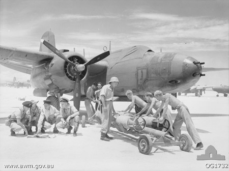
No.
22 Squadron aircrew and ground crew preparing for a sortie in October
1944 |
Location - Charters Towers, Queensland
Elevation AMSL 955 ft / m
Coordinates 20°02′35″S 146°16′23″E
Runways
---
Direction - 19/01
Length - 1,005 m, 3,297 ft
---
Direction - 24/06
Length - 1,737 m, 5,699 ft
---
Charters Towers is a city in northern Queensland, Australia.
It is located 137 kilometers inland (south-west) from Townsville on the
Flinders Highway. In 2006 the population was 7,979 people, some 450 fewer
than in the 2001 census.
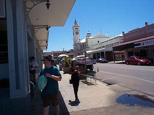 |
City centre
with Post Office in background
(Click on the photo to enlarge)
|
Images and information placed above are from
http://en.wikipedia.org/wiki/Charters_Towers_Airport
We thank them for the data!
Wikipedia licensing
| General Info
|
| Country |
Australia
|
| ICAO ID |
YCHT
|
| Time |
UTC+10
|
| Latitude |
-20.043056
20° 02' 35.00" S
|
| Longitude |
146.273056
146° 16' 23.00" E
|
| Elevation |
955 feet
291 meters
|
| Magnetic Variation |
007° E (05/06)
|
| Operating Agency |
CIVIL GOVERNMENT, (LANDING FEES AND DIPLOMATIC CLEARANCE MAY BE REQUIRED)
|
| Communications
|
| BRISBANE CNTR |
120.55
|
| CTAF |
126.7
|
| Communications Remarks |
|
| FSS |
(circuit area)
|
| Runways
|
| ID |
Dimensions |
Surface |
PCN |
ILS
|
| 01/19 |
3297 x 98 feet
1005 x 30 meters |
GRAVEL. |
- |
NO
|
| 06/24 |
5695 x 100 feet
1736 x 30 meters |
ASPHALT |
007FAYU |
NO
|
| Supplies/Equipment
|
| Fuel |
Jet A1, without icing nhibitor.
100/130 MIL Spec, low lead, aviation gasoline (BLUE)
|
| Remarks
|
| CAUTION |
Bird and animal haz. Glider ops SR-SS Sat, Sun and hol.
|
| FUEL |
(NC-100LL) fone C074-787-3293.
|
| LGT |
ACTIVATE-Rwy 06-24- 125.3. Portable lgt, emerg, on req.
|
| MISC |
Arpt fone C074-787-2897. Ldg fees
|
The content above was published at Airports-Worldwide.com in 2010.
We don't guarantee the information is fresh and accurate. The data may be wrong or outdated.
For more up-to-date information please refer to other sources.
|
 |