 |
 |
|
||||
|
Cairns Port Authority owns and operates Cairns International Airport. The airport operates:
 Operator: Cairns Port Authority
Address: PO Box 594 Cairns QLD 4870 Australia Phone: +61 7 40523888 Fax: +61 7 40359106 Email: marketing at cairnsport com au URL: Cairns Airport Images and information placed above are from Cairns Airport We thank them for the data!
Runway 12/303035 x 60 feet
|
||||||||||||||||||||||||||||||||||||||||||||||||||||||||||||||||||||||||||||||||||||||||||||||||||||||||||||||||||||||||||||||||||||||||||||||||||||||||||||||||||||||||||||||||||||||||||||||||||||||||||||||||||||||||||||||||||||||||||||||||||||||||||||||||||||||||||||||||||||||||||||||||||||||||
| Runway 12 | |
|---|---|
| Surface | ASPHALT |
| True Heading | 126.0 |
| Latitude | -16.880672 16° 52' 50.42" S |
| Longitude | 145.752128 145° 45' 07.66" E |
| Elevation | 9.0 feet 3 meters |
| Slope | -0.1° |
| Landing Distance | 3035 feet 925 meters |
| Takeoff Distance | 3035 feet 925 meters |
| Runway 30 | |
|---|---|
| Surface | ASPHALT |
| True Heading | 306.0 |
| Latitude | -16.885550 16° 53' 07.98" S |
| Longitude | 145.759192 145° 45' 33.09" E |
| Elevation | 6.0 feet 2 meters |
| Slope | 0.1° |
| Landing Distance | 3035 feet 925 meters |
| Takeoff Distance | 3035 feet 925 meters |
| Runway 15 | |
|---|---|
| Surface | ASPHALT |
| True Heading | 156.0 |
| Latitude | -16.865842 16° 51' 57.03" S |
| Longitude | 145.743567 145° 44' 36.84" E |
| Elevation | 9.0 feet 3 meters |
| Slope | 0.0° |
| Landing Distance | 10489 feet 3197 meters |
| Takeoff Distance | 10689 feet 3258 meters |
| Overrun Length | 200 feet 61 meters |
| Overrun Surface | ASPHALT |
| Lighting System | HIRL
A1 VA |
| Runway 33 | |
|---|---|
| Surface | ASPHALT |
| True Heading | 336.0 |
| Latitude | -16.892314 16° 53' 32.33" S |
| Longitude | 145.755542 145° 45' 19.95" E |
| Elevation | 7.0 feet 2 meters |
| Slope | 0.0° |
| Landing Distance | 10489 feet 3197 meters |
| Takeoff Distance | 10689 feet 3258 meters |
| Overrun Length | 200 feet 61 meters |
| Overrun Surface | ASPHALT |
| Lighting System | MIRL
VA |
| CAIRNS | |||||
|---|---|---|---|---|---|
| Type | ID | Channel | Freq | Country | State |
| VOR-DME | OZR | 049X | 111.2 | United States | ALABAMA |
| Latitude | Longitude | Airport |
| 31.268950 31° 16' 08.22" N |
-85.726317 085° 43' 34.74" W |
KOZR |
| CAIRNS | |||||
|---|---|---|---|---|---|
| Type | ID | Channel | Freq | Country | State |
| NDB | CS | - | 364 | Australia | - |
| Latitude | Longitude | Airport |
| -16.846944 16° 50' 49.00" S |
145.735556 145° 44' 08.00" E |
YBCS |
| CAIRNS | |||||
|---|---|---|---|---|---|
| Type | ID | Channel | Freq | Country | State |
| VOR-DME | CS | 077X | 113 | Australia | - |
| Latitude | Longitude | Airport |
| -16.850000 16° 51' 00.00" S |
145.744167 145° 44' 39.00" E |
YBCS |
The content above was published at Airports-Worldwide.com in 2004-2006.
We don't guarantee the information is fresh and accurate. The data may be wrong or outdated.
For more up-to-date information please refer to other sources.

 |
|
Copyright 2004-2024 © by Airports-Worldwide.com, Vyshenskoho st. 36, Lviv 79010, Ukraine Legal Disclaimer |
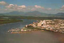
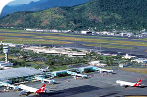 Cairns is the heart of the Tropical North, and as such provides an ideal base for exploring and enjoying the rich, varied pleasures of this region. The Cairns International Airport, a short ride from the city centre, acts as a gateway to the city and a primary access point to the Great Barrier Reef.