 |
 |
|
||||
|
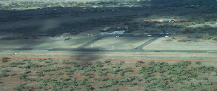
Bourke Airport (IATA: BRK, ICAO: YBKE) is an airport
in Bourke, New South Wales, Australia. Airlines and destinations * Regional Express
Latitude: 30 deg 02.3'S Longitude: 145 deg 57.1'E Magnetic Variation: 10 deg E Type of Airfield: Public Elevation: 352 feet WAC Chart: 3356 Runway Information: 05/23 Bitumen 1830m, 18/36 Natural 1000m (15m wide) Lighting: PAL 119.6 05/23 only Windsock: Yes, N end Special Procedures: Animal and bird hazard. Refer also to ERSA Landing Permission: Not required Landing Fees: Nil Fuel: Avgas and Jet A1 24Hr Shell swipe card. Toilets: 24Hr Access Public Phone: Available Drinking Water: Yes Nearest Town: Bourke 4Km South Contact details Images and information placed above are from Bourke Airport http://en.wikipedia.org/wiki/Bourke_Airport We thank them for the data!
Runway 05/236004 x 98 feet
|
|||||||||||||||||||||||||||||||||||||||||||||||||||||||||||||||||||||||||||||||||||||||||||||||||||||||||||||||||||||||||||||||||||||||||||||||||||||||||||||||||||||||||||||||||||||||||||||||||||||||||||||||||||||||||||||||
| Runway 05 | |
|---|---|
| Surface | ASPHALT |
| True Heading | 063.0 |
| Latitude | -30.044919 30° 02' 41.71" S |
| Longitude | 145.936872 145° 56' 12.74" E |
| Elevation | 350.0 feet 107 meters |
| Slope | 0.0° |
| Landing Distance | 6004 feet 1830 meters |
| Takeoff Distance | 6204 feet 1891 meters |
| Overrun Length | 200 feet 61 meters |
| Overrun Surface | GRADED OR ROLLED EARTH, GRASS ON GRADED EARTH. |
| Lighting System | PCL LIRL PORTABLE |
| Runway 23 | |
|---|---|
| Surface | ASPHALT |
| True Heading | 243.0 |
| Latitude | -30.037336 30° 02' 14.41" S |
| Longitude | 145.953694 145° 57' 13.30" E |
| Elevation | 351.0 feet 107 meters |
| Slope | 0.0° |
| Landing Distance | 6004 feet 1830 meters |
| Takeoff Distance | 6204 feet 1891 meters |
| Overrun Length | 200 feet 61 meters |
| Overrun Surface | GRADED OR ROLLED EARTH, GRASS ON GRADED EARTH. |
| Lighting System | PCL LIRL PORTABLE |
| Runway 18 | |
|---|---|
| Surface | GRASS OR EARTH NOT GRADED OR ROLLED. |
| True Heading | 188.0 |
| Latitude | -30.032394 30° 01' 56.62" S |
| Longitude | 145.957083 145° 57' 25.50" E |
| Landing Distance | 3281 feet 1000 meters |
| Takeoff Distance | 3381 feet 1031 meters |
| Overrun Length | 100 feet 30 meters |
| Overrun Surface | GRADED OR ROLLED EARTH, GRASS ON GRADED EARTH. |
| Runway 36 | |
|---|---|
| Surface | GRASS OR EARTH NOT GRADED OR ROLLED. |
| True Heading | 008.0 |
| Latitude | -30.041336 30° 02' 28.81" S |
| Longitude | 145.955706 145° 57' 20.54" E |
| Landing Distance | 3281 feet 1000 meters |
| Takeoff Distance | 3381 feet 1031 meters |
| Overrun Length | 100 feet 30 meters |
| Overrun Surface | GRADED OR ROLLED EARTH, GRASS ON GRADED EARTH. |
| BOURKE | |||||
|---|---|---|---|---|---|
| Type | ID | Channel | Freq | Country | State |
| NDB | BKE | - | 389 | Australia | - |
| Latitude | Longitude | Airport |
| -30.043333 30° 02' 36.00" S |
145.949444 145° 56' 58.00" E |
YBKE |
The content above was published at Airports-Worldwide.com in 2004-2006.
We don't guarantee the information is fresh and accurate. The data may be wrong or outdated.
For more up-to-date information please refer to other sources.

 |
|
Copyright 2004-2024 © by Airports-Worldwide.com, Vyshenskoho st. 36, Lviv 79010, Ukraine Legal Disclaimer |
 Operator: Bourke Shire Council