 |
 |
|
||||
|
Ayers Rock Airport (also known as Connellan Airport) (IATA: AYQ, ICAO: YAYE) is situated near Yulara, around 463 km (288 mi) (5 hrs drive) away from Alice Springs, Northern Territory, and 20 minutes drive from Uluru (Ayers Rock) itself. An average of 400,000 passenger movements per year pass through this airport in the middle of Australia.
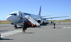
Airport facilitiesAyers Rock Airport has one main terminal for scheduled flights which contains: Check-in, Customs Baggage Screening, a single Baggage collection conveyor belt, a National Geographic shop, vending machines, Toilets, Departure and Arrival areas, Bus bays and Short term parking. The largest aircraft that Ayers Rock Airport caters for is Boeing 737-800s operated by Qantas. QantasLink operate a number of Boeing 717-200s in and out of the airport. Technical aspectsThe runway at Ayers Rock Airport is 2,599 × 30 m (8,527 × 98 ft). It has a simple, single stage lighting system and T-VASIS. Airlines and destinations
In addition, there are a wide number of scenic flights that are offered by different private charters. Qantas operates Boeing 737-400/800's, while Qantaslink operates Boeing 717-200's in and out of Ayers Rock Airport. All Qantaslink services are operated by National Jet Systems. Other aviationThe main user of the airport are light aircraft- either charter, scenic flights or private owned aircraft.
Images and information placed above are from www.airportsaustralia.com www.bentom.com http://en.wikipedia.org/wiki/Ayers_Rock_Airport We thank them for the data!
Runway 18/3610000 x 148 feet
|
|||||||||||||||||||||||||||||||||||||||||||||||||||||||||||||||||||||||||||||||||||||||||||||||||||||||||||||||||||||||||||||||||||||||||||||||||||||||||||||||||||||||||||||||||||||||||||||||||||||||||||||||||||||||||||||||||||||||||||||||||||||||||||||||||||||||||||
| Runway 18 | |
|---|---|
| Surface | ASPHALT |
| True Heading | 188.0 |
| Latitude | -38.027239 38° 01' 38.06" S |
| Longitude | 144.469425 144° 28' 09.93" E |
| Elevation | 31.0 feet 9 meters |
| Slope | 0.0° |
| Landing Distance | 10000 feet 3048 meters |
| Takeoff Distance | 10000 feet 3048 meters |
| Lighting System | PCL
MIRL PAPI |
| Runway 36 | |
|---|---|
| Surface | ASPHALT |
| True Heading | 008.0 |
| Latitude | -38.054456 38° 03' 16.04" S |
| Longitude | 144.464839 144° 27' 53.42" E |
| Elevation | 34.0 feet 10 meters |
| Slope | 0.0° |
| Landing Distance | 10000 feet 3048 meters |
| Takeoff Distance | 10000 feet 3048 meters |
| Lighting System | PCL
MIRL VA PAPI |
| AVALON | |||||
|---|---|---|---|---|---|
| Type | ID | Channel | Freq | Country | State |
| NDB | AV | - | 404 | Australia | - |
| Latitude | Longitude | Airport |
| -38.018056 38° 01' 05.00" S |
144.471111 144° 28' 16.00" E |
YMAV |
| AVALON | |||||
|---|---|---|---|---|---|
| Type | ID | Channel | Freq | Country | State |
| VOR-DME | AV | 108X | 116.1 | Australia | - |
| Latitude | Longitude | Airport |
| -38.048889 38° 02' 56.00" S |
144.458889 144° 27' 32.00" E |
YMAV |
| RIPLEY | |||||
|---|---|---|---|---|---|
| Type | ID | Channel | Freq | Country | State |
| NDB | XCR | - | 404 | United States | MINNESOTA |
| Latitude | Longitude | Airport |
| 46.078578 46° 04' 42.88" N |
-94.343336 094° 20' 36.01" W |
RYM |
| RIPLEY | |||||
|---|---|---|---|---|---|
| Type | ID | Channel | Freq | Country | State |
| NDB | RPY | - | 224 | Australia | - |
| Latitude | Longitude | Airport |
| -37.892500 37° 53' 33.00" S |
144.491944 144° 29' 31.00" E |
YMAV |
The content above was published at Airports-Worldwide.com in 2004-2006.
We don't guarantee the information is fresh and accurate. The data may be wrong or outdated.
For more up-to-date information please refer to other sources.

 |
|
Copyright 2004-2024 © by Airports-Worldwide.com, Vyshenskoho st. 36, Lviv 79010, Ukraine Legal Disclaimer |

 Operator: Ayers Rock Resort Management
 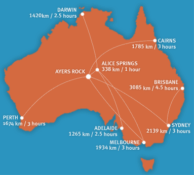 Ayers Rock Airport is conveniently located just 6Km from Ayers Rock Resort
(10 minutes travel). The airport services both fixed and rotary winged
aircraft and receives up to on average 350,000 - 400,000 commercial passengers
per year. It is also a popular stopping off point for private pilots and
passengers travelling in their own aircraft.
Ayers Rock Airport is conveniently located just 6Km from Ayers Rock Resort
(10 minutes travel). The airport services both fixed and rotary winged
aircraft and receives up to on average 350,000 - 400,000 commercial passengers
per year. It is also a popular stopping off point for private pilots and
passengers travelling in their own aircraft.