|
|
Uíge/Carmona Airport (IATA: UGO, ICAO: FNUG) is a public use airport on the west side of Uíge, the capital of Uíge Province in Angola.
The runway additionally has a 65 metres (213 ft) displaced threshold on each end.
The Uíge non-directional beacon (Ident: UG) is located 2.2 nautical miles south of the runway.
|
Uíge Airport
Carmona Airport
|
|
|
| Summary |
| Airport type |
Public |
| Operator |
Government |
| Location |
Uíge, Angola |
| Elevation AMSL |
2,720 ft / 829 m |
| Coordinates |
7°36′10″S
15°1′40″E |
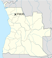
| Map |
Location of Uíge/Carmona Airport in Angola
|
| Runways |
| Direction |
Length |
Surface |
| ft |
m |
| 01/19 |
7,398 |
2,255 |
Asphalt |
|
The above content comes from Wikipedia and is published under free licenses – click here to read more.
| General Info
|
| Country |
Angola
|
| ICAO ID |
FNUG
|
| Time |
UTC+1
|
| Latitude |
-7.603067
07° 36' 11.04" S
|
| Longitude |
15.027822
015° 01' 40.16" E
|
| Elevation |
2720 feet
829 meters
|
| Magnetic Variation |
004° W (05/06)
|
| Operating Agency |
CIVIL GOVERNMENT, (LANDING FEES AND DIPLOMATIC CLEARANCE MAY BE REQUIRED)
|
| Operating Hours |
SUNRISE TO SUNSET (SR-SS)
|
| Runways
|
| ID |
Dimensions |
Surface |
PCN |
ILS
|
| 01/19 |
6562 x 55 feet
2000 x 17 meters |
ASPHALT |
- |
NO
|
| Navaids
|
| Type |
ID |
Name |
Channel |
Freq |
Distance From Field |
Bearing From Navaid
|
| NDB |
UG |
UIGE |
- |
300 |
2.0 NM |
193.0
|
| Supplies/Equipment
|
| Fuel |
Jet B, Wide cut turbine fuel, Without icing inhibitor.
100/130 MIL Spec, low lead, aviation gasoline (BLUE)
|
| Remarks
|
| FUEL |
(NC-80, 100LL, B)
|
| OPR HOURS |
Opr SR-SS.
|
The content above was published at Airports-Worldwide.com in 2020.
We don't guarantee the information is fresh and accurate. The data may be wrong or outdated.
For more up-to-date information please refer to other sources.
|
|