|
|
Saurimo Airport (Henrique de Carvalho) |
Saurimo Airport (Henrique de Carvalho) (Portuguese: Aeroporto de Saurimo, (IATA: VHC, ICAO: FNSA)) is a public use airport serving the city of Saurimo in Lunda Sul Province, Angola. It was formerly known as Henrique de Carvalho Airport.
The Saurimo VOR-DME (Ident: VSA) is located on the field. The Saurimo non-directional beacon (Ident: SA) is located 1.57 nautical miles (2,910 m) off the Runway 13 threshold.
|
Saurimo Airport (Henrique de Carvalho)
Henrique de Carvalho Airport
|
|
|
| Summary |
| Airport type |
Public |
| Serves |
Saurimo |
| Elevation AMSL |
3,586 ft / 1,093 m |
| Coordinates |
9°41′20″S
20°25′55″E |
| Map |
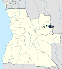
Location of Saurimo Airport (Henrique de Carvalho) in Angola
|
| Runways |
| Direction |
Length |
Surface |
| m |
ft |
| 13/31 |
3,402 |
11,161 |
Asphalt |
|
Airlines and destinations
| Destinations |
| Fly Angola |
Luanda |
| TAAG Angola Airlines |
Luanda |
The above content comes from Wikipedia and is published under free licenses – click here to read more.
| General Info
|
| Country |
Angola
|
| ICAO ID |
FNSA
|
| Time |
UTC+1
|
| Latitude |
-9.689067
09° 41' 20.64" S
|
| Longitude |
20.431875
020° 25' 54.75" E
|
| Elevation |
3584 feet
1092 meters
|
| Type |
Civil
|
| Magnetic Variation |
003° W (05/06)
|
| Operating Agency |
CIVIL GOVERNMENT, (LANDING FEES AND DIPLOMATIC CLEARANCE MAY BE REQUIRED)
|
| Operating Hours |
SUNRISE TO SUNSET (SR-SS)
|
| Communications
|
| AFIS |
118.1
|
| Runways
|
| ID |
Dimensions |
Surface |
PCN |
ILS
|
| 14/32 |
11155 x 148 feet
3400 x 45 meters |
ASPHALT |
- |
NO
|
| Navaids
|
| Type |
ID |
Name |
Channel |
Freq |
Distance From Field |
Bearing From Navaid
|
| NDB |
SA |
SAURIMO |
- |
367 |
2.5 NM |
130.0
|
| Supplies/Equipment
|
| Fuel |
80/87 octane gasoline, leaded, MIL-L-5572F (RED)
Jet fuel avaiable but type is unknown.
100/130 MIL Spec, low lead, aviation gasoline (BLUE)
|
| Remarks
|
| FUEL |
(NC-80, 100LL, J)
|
| OPR HOURS |
Opr SR-SS and O/R.
|
The content above was published at Airports-Worldwide.com in 2020.
We don't guarantee the information is fresh and accurate. The data may be wrong or outdated.
For more up-to-date information please refer to other sources.
|
|